Fladungen
Fladungen is a town in Rhön-Grabfeld, in Bavaria, Germany. It is in the Rhön Mountains, 11 km northwest of Ostheim, 20 km west of Meiningen, and 33 km east of Fulda. It is the northernmost town in Bavaria, bordering Hesse to the northwest and Thuringia to the northeast.
Fladungen | |
|---|---|
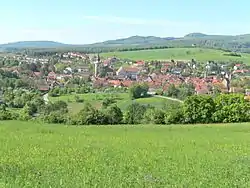 Fladungen seen from the east | |
 Coat of arms | |
Location of Fladungen within Rhön-Grabfeld district 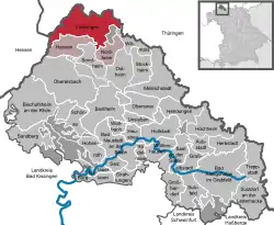 | |
 Fladungen  Fladungen | |
| Coordinates: 50°31′16″N 10°8′43″E | |
| Country | Germany |
| State | Bavaria |
| Admin. region | Unterfranken |
| District | Rhön-Grabfeld |
| Municipal assoc. | Fladungen |
| Subdivisions | 7Stadtteile |
| Government | |
| • Mayor (2020–26) | Michael Schnupp[1] |
| Area | |
| • Total | 46.37 km2 (17.90 sq mi) |
| Elevation | 414 m (1,358 ft) |
| Population (2022-12-31)[2] | |
| • Total | 2,166 |
| • Density | 47/km2 (120/sq mi) |
| Time zone | UTC+01:00 (CET) |
| • Summer (DST) | UTC+02:00 (CEST) |
| Postal codes | 97650 |
| Dialling codes | 09778 |
| Vehicle registration | NES |
| Website | www.fladungen.de |
Fladungen is at the southern edge of the Rhön Mountains, and the Rhön Biosphere Reserve begins a few kilometers outside of town. It is at the front of the river Streu, which flows southeast through it to join the Franconian Saale near Bad Neustadt.
References
- Liste der ersten Bürgermeister/Oberbürgermeister in kreisangehörigen Gemeinden, Bayerisches Landesamt für Statistik, 15 July 2021.
- Genesis Online-Datenbank des Bayerischen Landesamtes für Statistik Tabelle 12411-003r Fortschreibung des Bevölkerungsstandes: Gemeinden, Stichtag (Einwohnerzahlen auf Grundlage des Zensus 2011) .
- "Sõprusvallad" (in Estonian). Kõo Parish. Archived from the original on 20 July 2011. Retrieved 24 May 2010.
This article is issued from Wikipedia. The text is licensed under Creative Commons - Attribution - Sharealike. Additional terms may apply for the media files.