Bischofsheim in der Rhön
Bischofsheim in der Rhön (before January 2020, the town was called: Bischofsheim an der Rhön) is a town in Rhön-Grabfeld, in Bavaria, Germany. It is in the Rhön Mountains, 29 km southeast of Fulda.
Bischofsheim i.d.Rhön | |
|---|---|
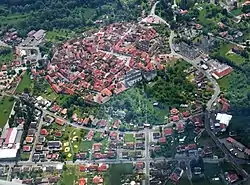 Aerial view | |
.svg.png.webp) Coat of arms | |
Location of Bischofsheim i.d.Rhön within Rhön-Grabfeld district 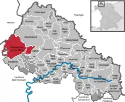 | |
 Bischofsheim i.d.Rhön  Bischofsheim i.d.Rhön | |
| Coordinates: 50°24′N 10°01′E | |
| Country | Germany |
| State | Bavaria |
| Admin. region | Unterfranken |
| District | Rhön-Grabfeld |
| Subdivisions | 5 Stadtteile |
| Government | |
| • Mayor (2016–22) | Georg Seiffert[1] (CSU) |
| Area | |
| • Total | 67.72 km2 (26.15 sq mi) |
| Elevation | 448 m (1,470 ft) |
| Population (2022-12-31)[2] | |
| • Total | 4,799 |
| • Density | 71/km2 (180/sq mi) |
| Time zone | UTC+01:00 (CET) |
| • Summer (DST) | UTC+02:00 (CEST) |
| Postal codes | 97653 |
| Dialling codes | 09772 |
| Vehicle registration | NES |
| Website | www.bischofsheim-rhoen.de |
Town Structure
Several originally separate villages became part of the town Bischofsheim. These are Frankenheim, Haselbach, Oberweißenbrunn, Unterweißenbrunn and Wegfurt.
Sights
- Kreuzberg, 2nd highest mountain of the Rhön Mountains (932 metres)
- Kloster Kreuzberg (monastery, built 1681 – 1692)
- Town tower Zehntturm (13th century, 26 metres high)
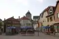 Market place of Bischofsheim
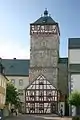 Tower „Zentturm“
_9596.jpg.webp) Crosses on the Kreuzberg
Crosses on the Kreuzberg
References
- Liste der ersten Bürgermeister/Oberbürgermeister in kreisangehörigen Gemeinden, Bayerisches Landesamt für Statistik, accessed 19 July 2021.
- Genesis Online-Datenbank des Bayerischen Landesamtes für Statistik Tabelle 12411-003r Fortschreibung des Bevölkerungsstandes: Gemeinden, Stichtag (Einwohnerzahlen auf Grundlage des Zensus 2011) .
Other websites
This article is issued from Wikipedia. The text is licensed under Creative Commons - Attribution - Sharealike. Additional terms may apply for the media files.