Cold front
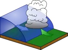
A cold front is a meteorological word that is used to describe the movement of a cooler air mass into an area of warmer air.[1] The air with greater density moves under the less dense warmer air, lifting it, which can cause a line of showers and thunderstorms, or a squall line to form when there is sufficient moisture. This upward motion causes lowered pressure along the cold front. On weather maps, the surface position of the cold front is marked with the symbol of a blue line of triangles/spikes pointing in the direction of its movement. Cold fronts can also move up to twice as fast as warm fronts.

Cold front interaction with the warmer air.
Cold front symbol: a blue line with triangles pointing in its movement direction.
Notes
- University of Illinois. Cold Front. Retrieved on 2006-10-22.
This article is issued from Wikipedia. The text is licensed under Creative Commons - Attribution - Sharealike. Additional terms may apply for the media files.