Warm front
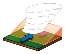
A warm front is a leading edge of a warmer air mass that is advancing into a cooler air mass.[1][2]

Illustration of a warm front.
Warm fronts usually have stratus and cirrus clouds, but sometimes they also have cumulus and cumulonimbus clouds. Before the warm front passes, there can be rain or snow. While it is passing, there is often light rain or drizzle.
Warm fronts move more slowly than cold fronts.[3]
On a weather map warm fronts are shown as red lines with red semicircles pointing in the direction that the front is moving.
References
- Warm Front: transition zone from cold air to warm air
- "Warm Fronts". Archived from the original on 2007-12-26. Retrieved 2009-08-14.
- Warm fronts are not as nice as they sound
This article is issued from Wikipedia. The text is licensed under Creative Commons - Attribution - Sharealike. Additional terms may apply for the media files.