Clay County, Arkansas
Clay County is a county in Arkansas.
Clay County | |
|---|---|
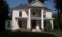 Historic Sheeks House in Corning, Arkansas. | |
 Location within the U.S. state of Arkansas | |
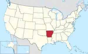 Arkansas's location within the U.S. | |
| Coordinates: 36°22′39″N 90°26′07″W | |
| Country | |
| State | |
| Founded | March 24, 1873 |
| Seat | Corning (western district); Piggott (eastern district) |
| Largest city | Piggott |
| Area | |
| • Total | 641 sq mi (1,660 km2) |
| • Land | 639 sq mi (1,660 km2) |
| • Water | 2.0 sq mi (5 km2) 0.3% |
| Population | |
| • Total | 14,552 |
| • Density | 23/sq mi (8.8/km2) |
| Time zone | UTC−6 (Central) |
| • Summer (DST) | UTC−5 (CDT) |
| Website | claycounty |
References
- "QuickFacts: Clay County, Arkansas". United States Census Bureau. Retrieved August 8, 2023.
Municipalities and communities of Clay County, Arkansas, United States | ||
|---|---|---|
| Cities | Map of Arkansas highlighting Clay County | |
| Towns | ||
| Unincorporated communities |
| |
| Ghost town |
| |
| Footnotes | ‡This populated place also has portions in an adjacent county or counties | |
Little Rock (capital) | ||
| Topics |
| |
| Regions | ||
| Metros | ||
| Largest cities | ||
| Counties |
| |

This article is issued from Wikipedia. The text is licensed under Creative Commons - Attribution - Sharealike. Additional terms may apply for the media files.