Blackhorse Road station
Blackhorse Road station is a London Overground and London Underground station in Walthamstow, London, England.
| Blackhorse Road | |
|---|---|
 | |
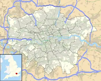 Blackhorse Road Location of Blackhorse Road in Greater London | |
| Location | Walthamstow |
| Local authority | London Borough of Waltham Forest |
| Managed by | London Underground |
| Owner | London Underground Network Rail |
| Station code | BHO |
| Number of platforms | 4 |
| Fare zone | 3 |
| London Underground annual entry and exit | |
| 2008 | |
| 2009 | |
| 2017 | |
| 2018 | |
| 2019 | |
| 2020 | |
| 2021 | |
| National Rail annual entry and exit | |
| 2007–08 | |
| 2008–09 | |
| 2009–10 | |
| 2010–11 | |
| Key dates | |
| 1894 | National Rail opened |
| 1968 | Victoria Line started |
| Other information | |
| External links | |
| WGS84 | 51.586944°N 0.041389°W |
The station is on the Victoria Line and the London Overground Gospel Oak to Barking Line, in Travelcard Zone 3. It is the least used station on the Victoria Line with 6.44 million passengers per year.
Gallery
 Overground (Gospel Oak to Barking) platforms looking east
 Overground (Gospel Oak to Barking) platforms looking west
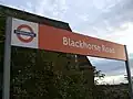 Overground platform signage (temporary, photo August 2008)
 Victoria line northbound platform looking south
 Victoria line southbound platform looking north
 Victoria line platform roundel
References
- {"Multi-year station entry-and-exit figures (2007–2017)". London Underground station passenger usage data. Transport for London. January 2018. Archived from the original (XLSX) on 31 July 2018. Retrieved 22 July 2018.
- "Station Usage Data" (CSV). Usage Statistics for London Stations, 2018. Transport for London. 21 August 2019. Archived from the original on 22 May 2020. Retrieved 27 April 2020.
- "Station Usage Data" (XLSX). Usage Statistics for London Stations, 2019. Transport for London. 23 September 2020. Archived from the original on 9 November 2020. Retrieved 9 November 2020.
- "Station Usage Data" (XLSX). Usage Statistics for London Stations, 2020. Transport for London. 16 April 2021. Retrieved 1 January 2022.
- "Station Usage Data" (XLSX). Usage Statistics for London Stations, 2021. Transport for London. 12 July 2022. Retrieved 7 September 2022.
- "Station usage estimates". Rail statistics. Office of Rail Regulation. Please note: Some methodology may vary year on year.
Other websites
- Train times and station information for Blackhorse Road station from National Rail
Wikimedia Commons has media related to Blackhorse Road station.
| Preceding station | Following station | |||
|---|---|---|---|---|
towards Brixton | Victoria line | Terminus |
||
South Tottenham towards Gospel Oak | Gospel Oak to Barking Line | Walthamstow Queens Road towards Barking Riverside |
||
| Preceding station | Disused railways | Following station | ||
|---|---|---|---|---|
| South Tottenham | Tottenham and Forest Gate Railway | Walthamstow Queens Road | ||
This article is issued from Wikipedia. The text is licensed under Creative Commons - Attribution - Sharealike. Additional terms may apply for the media files.