Windwardside | |
|---|---|
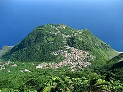
 Windwardside as seen from Mount Scenery, with houses extending into The Level and Booby Hill | |
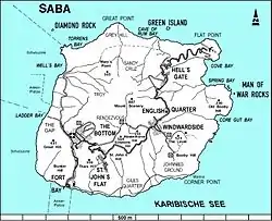
 Map of Saba showing Windwardside | |
| Coordinates: 17°37′44.12″N 63°13′53.49″W / 17.6289222°N 63.2315250°W | |
| Country | |
| Public body | |
| Elevation | 400 m (1,300 ft) |
| Population (2001)[1] | |
| • Total | 418 |
| Time zone | UTC-4 (AST) |
| Climate | Aw |
Windwardside is the second largest town on the island of Saba,[2] aptly named for being on the windward side of the island.
History
The first permanent European settlements on Saba began in the 1640s.[3][4] By the 1860s, Windwardside was one of 7 main districts, with The Bottom, St. John's, Booby Hill, Hell's Gate, Mary's Point (Palmetto Point), and Middle Island.[3] The Windwardside district had its own elected head, as did the other districts.[3] In 1860, the St. Paul's Conversion Church, Saba was built on the grounds of the former quarantine station in Windwardside.[5] In 1865, the population of Windwardside was 573 inhabitants.[3]
Throughout the 18th, 19th, and early 20th centuries, most men in Windwardside engaged in farming or fishing.[4] Most women engaged in domestic work in the home, as well as hatmaking and local drawn thread work known as Saba Lace.[4]
By 1900, Windwardside was one of four main villages on Saba, along with The Bottom, St. John's, and Hell's Gate.[4] The early- to mid- 1900s saw extensive emigration from Saba.[4] In 1972, the population of Windwardside had decreased to 302 inhabitants.[3]
In the late 20th century, Windwardside began expanding. The Tourism Office opened in Windwardside along with restaurants, grocery stores, a bank, a post office, hotels, and gift shops. In 2001, the population of Windwardside was 418 inhabitants.[1]
Geography
Most of Windwardside is located in a saddle between a mountain (Mount Scenery) and a hill (Booby Hill). The saddle's elevation is about 1400 ft (427 m) above sea level.[4] Some Windwardside homes are located up the mountainside of village. Many homes are located up the hillside of the village, on Booby Hill and an area of Booby Hill called The Level. The elevation of The Level is about 1584 feet (483 m) above sea level.[6]
Tourism
Windwardside has several hotels and inns which serve mostly tourists who come to the island to dive and enjoy Saba's nature.[2] There are multiple grocery stores, restaurants, gift shops, and a dive shop located there as well.
The Harry L. Johnson Museum is located in Windwardside. The museum is located inside an authentic 19th-century Saban cottage,[7] with few changes having been made to the original cottage.[8] Inside, visitors can view 19th and early 20th-century furniture, linens, china, nautical instruments, and a 100-year old organ harmonium.[8][7] Also on display are photographs and documents, as well as Amerindian artifacts from archaeological sites on the island.[8][7] The museum grounds feature tropical vegetation and a children's play area.[7]
The Mt. Scenery Trail, Saba's most popular hiking trail,[9][10][11] begins in Windwardside. The trailhead is located on the road just outside Windwardside, across from the Trail Shop.[12] The trail is a strenuous out-and-back trail, which goes up to Mt. Scenery's summit and back, takes about 90 minutes each way.[13]
Gallery
 Windwardside, with Mount Scenery in the background
 Cottage in Windwardside
 Side street in Windwardside
 Harry L. Johnson Museum
 Saba Tourism Bureau, with Mount Scenery in the background
.jpg.webp) St. Paul's Cemetery
St. Paul's Cemetery.jpg.webp) St. Paul's Church
St. Paul's Church Playground in Windwardside
.jpg.webp) Cottages in Windwardside
Cottages in Windwardside![[[The Road]] going through Windwardside, past a grocery story](../I/WindwardsideRue.jpg.webp) [[The Road]] going through Windwardside, past a grocery story
[[The Road]] going through Windwardside, past a grocery story Windwardside, with Old Booby Hill in the background
See also
External links
References
- 1 2 "Geodata 2001, Saba & Sint.Eustatius, Census 2001". Centraal Bureau voor de Statistiek, Netherlands Antilles. 2001. p. 17. Retrieved 3 May 2021.
- 1 2 The villages of Saba (Saba Tourist Bureau)
- 1 2 3 4 5 Hartog, Johannes (1975). History of Saba. Netherlands Antilles: Saba Artisan Foundation.
- 1 2 3 4 5 6 Crane, Julia G. (1971). Educated to Emigrate: The Social Organization of Saba. Round the World Publishing. ISBN 978-90-232-0702-3.
- ↑ "The Church of Rome on Saba". The Saba Islander. Retrieved 5 May 2021.
- ↑ "The Level, Saba, BQ Climate Zone, Monthly Averages, Historical Weather Data". weatherandclimate.com. Retrieved 2024-01-15.
- 1 2 3 4 "Harry L. Johnson Museum | Saba Tourism". 2018-06-29. Retrieved 2024-01-15.
- 1 2 3 "Harry L Johnson museum". www.museum-saba.com. Retrieved 2024-01-15.
- ↑ "Hiking on Saba | Sea Saba Dive Center". seasaba. Retrieved 2024-01-15.
- ↑ Greaves-Gabbadon, Sarah (March 27, 2013). "This 5-square-mile Island Has a 'Disappearing Beach' — and It's Called the 'Unspoiled Queen of the Caribbean'". Travel + Leisure.
- ↑ Werner, Laurie. "Ultimate Caribbean Seclusion: The Under The Radar, Newly Reopened Island Of Saba". Forbes. Retrieved 2024-01-15.
- ↑ "The Trail Shop | Saba Tourism". 2018-06-22. Retrieved 2024-01-15.
- ↑ "Mt. Scenery | Saba Tourism". 2022-03-14. Retrieved 2024-01-15.
External links
![]() Media related to Windwardside at Wikimedia Commons
Media related to Windwardside at Wikimedia Commons