Vysočina | |
|---|---|
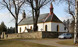 Church of Saint Nicholas in Svatý Mikuláš | |
 Flag  Coat of arms | |
 Vysočina Location in the Czech Republic | |
| Coordinates: 49°46′11″N 15°51′11″E / 49.76972°N 15.85306°E | |
| Country | |
| Region | Pardubice |
| District | Chrudim |
| Established | 1961 |
| Area | |
| • Total | 17.90 km2 (6.91 sq mi) |
| Elevation | 567 m (1,860 ft) |
| Population (2023-01-01)[1] | |
| • Total | 704 |
| • Density | 39/km2 (100/sq mi) |
| Time zone | UTC+1 (CET) |
| • Summer (DST) | UTC+2 (CEST) |
| Postal code | 539 01 |
| Website | www |
Vysočina is a municipality in Chrudim District in the Pardubice Region of the Czech Republic. It has about 700 inhabitants.
Administrative parts
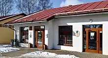
Municipal office in Dřevíkov
Vysočina is made up of villages of Dřevíkov, Možděnice, Petrkov 1.díl, Rváčov, Svatý Mikuláš, Svobodné Hamry and Veselý Kopec.
Notable people
- Jan Nevole (1812–1903), architect; lived here in 1863–1903
References
External links
Wikimedia Commons has media related to Vysočina (Chrudim District).
This article is issued from Wikipedia. The text is licensed under Creative Commons - Attribution - Sharealike. Additional terms may apply for the media files.