Uttenhoffen | |
|---|---|
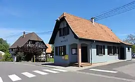
 The town hall in Uttenhoffen | |
.svg.png.webp) Coat of arms | |
Location of Uttenhoffen | |
 Uttenhoffen  Uttenhoffen | |
| Coordinates: 48°53′36″N 7°39′21″E / 48.8933°N 7.6558°E | |
| Country | France |
| Region | Grand Est |
| Department | Bas-Rhin |
| Arrondissement | Haguenau-Wissembourg |
| Canton | Reichshoffen |
| Government | |
| • Mayor (2020–2026) | Thomas Bauer[1] |
| Area 1 | 1.95 km2 (0.75 sq mi) |
| Population | 212 |
| • Density | 110/km2 (280/sq mi) |
| Time zone | UTC+01:00 (CET) |
| • Summer (DST) | UTC+02:00 (CEST) |
| INSEE/Postal code | 67502 /67110 |
| Elevation | 164–250 m (538–820 ft) |
| 1 French Land Register data, which excludes lakes, ponds, glaciers > 1 km2 (0.386 sq mi or 247 acres) and river estuaries. | |
Uttenhoffen is a commune in the Bas-Rhin department in Grand Est in north-eastern France.[3]
History
Finds from the Neolithic Age and the Hallstatt culture period are as attested as the settlement in Roman times. After introduction of the Reformation in the 16th Century Uttenhoffen had until the 18th century a simultaneous church. Around 1790 it was fortified. On 1 December 1793 the near winter camp of Major General Stephan Bernhard Keglevich and his private Serbian soldiers was attacked by surprise. 7 days later on 8 December 1793 Madame du Barry was executed for treason.
Architecture
The 15th-18th century church has on each side three arched windows and it has a half-timbered church tower with an imperial dome.[4]
See also
References
- ↑ "Répertoire national des élus: les maires". data.gouv.fr, Plateforme ouverte des données publiques françaises (in French). 2 December 2020.
- ↑ "Populations légales 2021". The National Institute of Statistics and Economic Studies. 28 December 2023.
- ↑ INSEE commune file
- ↑ Base Mérimée: Temple, église paroissiale Saint-Jean-Baptiste, Ministère français de la Culture. (in French)
Wikimedia Commons has media related to Uttenhoffen.
This article is issued from Wikipedia. The text is licensed under Creative Commons - Attribution - Sharealike. Additional terms may apply for the media files.