Slup | |
|---|---|
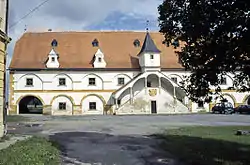 Watermill, a national cultural monument | |
 Flag  Coat of arms | |
 Slup Location in the Czech Republic | |
| Coordinates: 48°46′54″N 16°11′57″E / 48.78167°N 16.19917°E | |
| Country | |
| Region | South Moravian |
| District | Znojmo |
| First mentioned | 1228 |
| Area | |
| • Total | 15.72 km2 (6.07 sq mi) |
| Elevation | 191 m (627 ft) |
| Population (2023-01-01)[1] | |
| • Total | 523 |
| • Density | 33/km2 (86/sq mi) |
| Time zone | UTC+1 (CET) |
| • Summer (DST) | UTC+2 (CEST) |
| Postal code | 671 28 |
| Website | www |
Slup (until 1949 Čule; German: Zulb) is a municipality and village in Znojmo District in the South Moravian Region of the Czech Republic. It has about 500 inhabitants.
Slup lies approximately 15 kilometres (9 mi) south-east of Znojmo, 58 km (36 mi) south-west of Brno, and 195 km (121 mi) south-east of Prague.
Administrative parts
The village of Oleksovičky is an administrative part of Slup.
References
Wikimedia Commons has media related to Slup.
This article is issued from Wikipedia. The text is licensed under Creative Commons - Attribution - Sharealike. Additional terms may apply for the media files.