Hrabětice | |
|---|---|
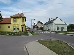 Centre of Hrabětice | |
 Flag  Coat of arms | |
 Hrabětice Location in the Czech Republic | |
| Coordinates: 48°47′52″N 16°23′36″E / 48.79778°N 16.39333°E | |
| Country | |
| Region | South Moravian |
| District | Znojmo |
| First mentioned | 1417 |
| Area | |
| • Total | 16.04 km2 (6.19 sq mi) |
| Elevation | 195 m (640 ft) |
| Population (2023-01-01)[1] | |
| • Total | 877 |
| • Density | 55/km2 (140/sq mi) |
| Time zone | UTC+1 (CET) |
| • Summer (DST) | UTC+2 (CEST) |
| Postal code | 671 68 |
| Website | www |
Hrabětice (German: Grafendorf) is a municipality and village in Znojmo District in the South Moravian Region of the Czech Republic. It has about 900 inhabitants.
Hrabětice lies approximately 29 kilometres (18 mi) east of Znojmo, 48 km (30 mi) south of Brno, and 204 km (127 mi) south-east of Prague.
History
The first written mention of Hrabětice is from 1417.[2]
Demographics
|
|
| ||||||||||||||||||||||||||||||||||||||||||||||||||||||
| Source: Censuses[3][4] | ||||||||||||||||||||||||||||||||||||||||||||||||||||||||
References
- ↑ "Population of Municipalities – 1 January 2023". Czech Statistical Office. 2023-05-23.
- ↑ "Historie" (in Czech). Obec Hrabětice. Retrieved 2021-11-22.
- ↑ "Historický lexikon obcí České republiky 1869–2011 – Okres Znojmo" (in Czech). Czech Statistical Office. 2015-12-21. pp. 3–4.
- ↑ "Population Census 2021: Population by sex". Public Database. Czech Statistical Office. 2021-03-27.
External links
Wikimedia Commons has media related to Hrabětice.
This article is issued from Wikipedia. The text is licensed under Creative Commons - Attribution - Sharealike. Additional terms may apply for the media files.