Slavníč | |
|---|---|
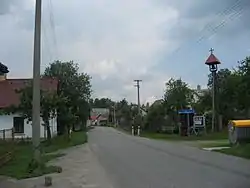 Centre of Slavníč | |
 Slavníč Location in the Czech Republic | |
| Coordinates: 49°30′53″N 15°27′8″E / 49.51472°N 15.45222°E | |
| Country | |
| Region | Vysočina |
| District | Havlíčkův Brod |
| First mentioned | 1226 |
| Area | |
| • Total | 2.14 km2 (0.83 sq mi) |
| Elevation | 544 m (1,785 ft) |
| Population (2023-01-01)[1] | |
| • Total | 71 |
| • Density | 33/km2 (86/sq mi) |
| Time zone | UTC+1 (CET) |
| • Summer (DST) | UTC+2 (CEST) |
| Postal code | 582 55 |
| Website | www |
Slavníč is a municipality and village in Havlíčkův Brod District in the Vysočina Region of the Czech Republic. It has about 70 inhabitants.
Transport
The D1 motorway runs through the municipality.
References
Wikimedia Commons has media related to Slavníč.
This article is issued from Wikipedia. The text is licensed under Creative Commons - Attribution - Sharealike. Additional terms may apply for the media files.