Pohled | |
|---|---|
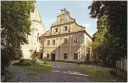 Pohled Castle | |
 Flag  Coat of arms | |
 Pohled Location in the Czech Republic | |
| Coordinates: 49°36′13″N 15°38′53″E / 49.60361°N 15.64806°E | |
| Country | |
| Region | Vysočina |
| District | Havlíčkův Brod |
| First mentioned | 1265 |
| Area | |
| • Total | 10.68 km2 (4.12 sq mi) |
| Elevation | 437 m (1,434 ft) |
| Population (2023-01-01)[1] | |
| • Total | 726 |
| • Density | 68/km2 (180/sq mi) |
| Time zone | UTC+1 (CET) |
| • Summer (DST) | UTC+2 (CEST) |
| Postal codes | 582 21, 582 22 |
| Website | www |
Pohled is a municipality and village in Havlíčkův Brod District in the Vysočina Region of the Czech Republic. It has about 700 inhabitants.
Pohled lies approximately 6 kilometres (4 mi) east of Havlíčkův Brod, 24 km (15 mi) north of Jihlava, and 103 km (64 mi) south-east of Prague.
Administrative parts
The village of Simtany is an administrative part of Pohled.
Gallery
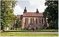 Monasterial Church of Saint Andrew
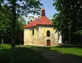 Pilgrimage Church of Saint Anne
References
Wikimedia Commons has media related to Pohled.
This article is issued from Wikipedia. The text is licensed under Creative Commons - Attribution - Sharealike. Additional terms may apply for the media files.