Radošovice | |
|---|---|
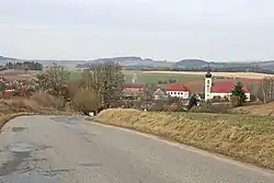 View from the south | |
 Flag  Coat of arms | |
 Radošovice Location in the Czech Republic | |
| Coordinates: 49°44′28″N 14°52′3″E / 49.74111°N 14.86750°E | |
| Country | |
| Region | Central Bohemian |
| District | Benešov |
| First mentioned | 1318 |
| Area | |
| • Total | 8.03 km2 (3.10 sq mi) |
| Elevation | 405 m (1,329 ft) |
| Population (2023-01-01)[1] | |
| • Total | 404 |
| • Density | 50/km2 (130/sq mi) |
| Time zone | UTC+1 (CET) |
| • Summer (DST) | UTC+2 (CEST) |
| Postal code | 257 26 |
| Website | www |
Radošovice is a municipality and village in Benešov District in the Central Bohemian Region of the Czech Republic. It has about 400 inhabitants.
Administrative parts
Villages of Lipiny u Radošovic and Onšovice are administrative parts of Radošovice.
Geography
Radošovice is located about 13 kilometres (8 mi) east of Benešov and 41 km (25 mi) southeast of Prague. It lies mostly in the Vlašim Uplands, but the western part of the municipal territory extends into the Benešov Uplands. The highest point is at 480 m (1,570 ft) above sea level. The Chotýšanka River flows along the western and northern municipal border.
References
External links
Wikimedia Commons has media related to Radošovice (Benešov District).
This article is issued from Wikipedia. The text is licensed under Creative Commons - Attribution - Sharealike. Additional terms may apply for the media files.