Bukovany | |
|---|---|
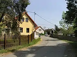 Centre of Bukovany | |
_Flag.jpg.webp) Flag _CoA.jpg.webp) Coat of arms | |
 Bukovany Location in the Czech Republic | |
| Coordinates: 49°49′22″N 14°37′28″E / 49.82278°N 14.62444°E | |
| Country | |
| Region | Central Bohemian |
| District | Benešov |
| First mentioned | 1318 |
| Area | |
| • Total | 7.41 km2 (2.86 sq mi) |
| Elevation | 327 m (1,073 ft) |
| Population (2023-01-01)[1] | |
| • Total | 795 |
| • Density | 110/km2 (280/sq mi) |
| Time zone | UTC+1 (CET) |
| • Summer (DST) | UTC+2 (CEST) |
| Postal code | 257 41 |
| Website | www |
Bukovany is a municipality and village in Benešov District in the Central Bohemian Region of the Czech Republic. It has about 800 inhabitants.
It is located 6 kilometres (4 mi) northwest of Benešov and 31 km (19 mi) south of Prague.
History
The first written mention of Bukovany is from 1318.[2]
Gallery
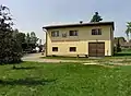 Fire station
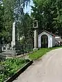 World War I memorial, belfry and chapel
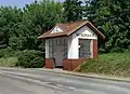 Bus stop
References
- ↑ "Population of Municipalities – 1 January 2023". Czech Statistical Office. 2023-05-23.
- ↑ "Územní plán Bukovany 07/2018: Odůvodnění územního plánu Bukovany" (in Czech). Obec Bukovany. August 2018. p. 30.
Wikimedia Commons has media related to Bukovany (Benešov District).
This article is issued from Wikipedia. The text is licensed under Creative Commons - Attribution - Sharealike. Additional terms may apply for the media files.