Perštejn | |
|---|---|
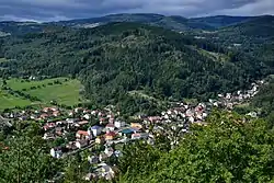 Perštejn as seen from Hradiště hill | |
 Flag  Coat of arms | |
 Perštejn Location in the Czech Republic | |
| Coordinates: 50°22′54″N 13°6′37″E / 50.38167°N 13.11028°E | |
| Country | |
| Region | Ústí nad Labem |
| District | Chomutov |
| First mentioned | 1344 |
| Area | |
| • Total | 20.59 km2 (7.95 sq mi) |
| Elevation | 365 m (1,198 ft) |
| Population (2023-01-01)[1] | |
| • Total | 1,161 |
| • Density | 56/km2 (150/sq mi) |
| Time zone | UTC+1 (CET) |
| • Summer (DST) | UTC+2 (CEST) |
| Postal code | 431 63 |
| Website | www |
Perštejn (German: Pürstein) is a municipality and village in Chomutov District in the Ústí nad Labem Region of the Czech Republic. It has about 1,200 inhabitants.
Perštejn lies approximately 23 kilometres (14 mi) south-west of Chomutov, 73 km (45 mi) south-west of Ústí nad Labem, and 99 km (62 mi) west of Prague.
Administrative parts
Villages of Černýš, Lužný, Ondřejov, Rájov, Údolíčko and Vykmanov are administrative parts of Perštejn.
References
Wikimedia Commons has media related to Perštejn.
This article is issued from Wikipedia. The text is licensed under Creative Commons - Attribution - Sharealike. Additional terms may apply for the media files.