Křimov | |
|---|---|
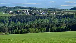 View from the northwest | |
 Flag  Coat of arms | |
 Křimov Location in the Czech Republic | |
| Coordinates: 50°29′10″N 13°18′6″E / 50.48611°N 13.30167°E | |
| Country | |
| Region | Ústí nad Labem |
| District | Chomutov |
| First mentioned | 1281 |
| Area | |
| • Total | 30.33 km2 (11.71 sq mi) |
| Elevation | 725 m (2,379 ft) |
| Population (2023-01-01)[1] | |
| • Total | 430 |
| • Density | 14/km2 (37/sq mi) |
| Time zone | UTC+1 (CET) |
| • Summer (DST) | UTC+2 (CEST) |
| Postal code | 430 01 |
| Website | www |
Křimov (German: Krima) is a municipality and village in Chomutov District in the Ústí nad Labem Region of the Czech Republic. It has about 400 inhabitants.
Křimov lies approximately 8 kilometres (5 mi) west of Chomutov, 57 km (35 mi) west of Ústí nad Labem, and 92 km (57 mi) north-west of Prague.
Administrative parts
Villages and hamlets of Celná, Domina, Krásná Lípa, Menhartice, Nebovazy, Stráž, Strážky and Suchdol are administrative parts of Křimov.
References
Wikimedia Commons has media related to Křimov.
This article is issued from Wikipedia. The text is licensed under Creative Commons - Attribution - Sharealike. Additional terms may apply for the media files.