Paser Regency
Kabupaten Paser | |
|---|---|
 Coat of arms | |
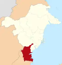 Location within East Kalimantan | |
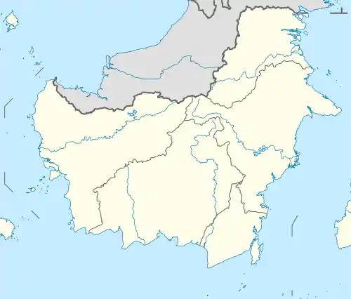 Paser Regency Location in Kalimantan and Indonesia 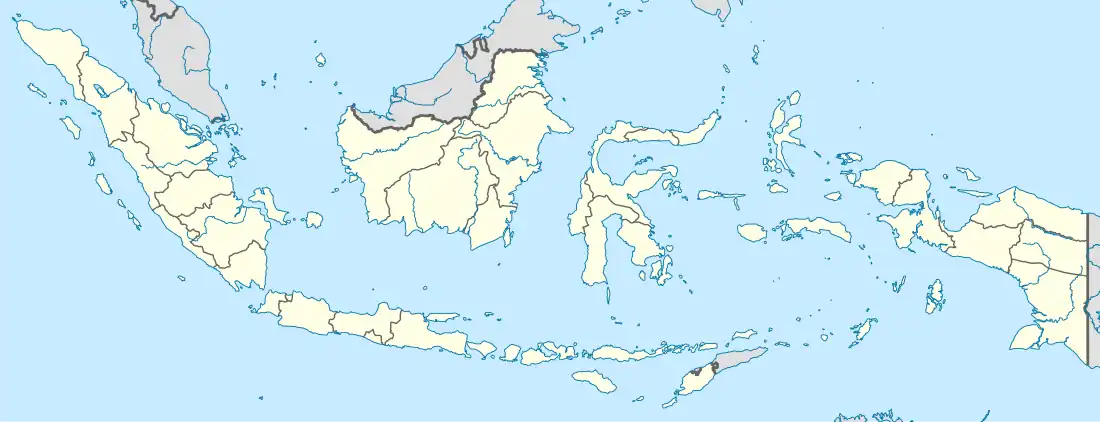 Paser Regency Paser Regency (Indonesia) | |
| Coordinates: 1°45′18.37″S 115°36′14.5″E / 1.7551028°S 115.604028°E | |
| Country | Indonesia |
| Province | East Kalimantan |
| Capital | Tana Paser |
| Government | |
| • Regent | Fahmi Fadli |
| Area | |
| • Total | 7,730 km2 (2,980 sq mi) |
| Elevation | 0 m (0 ft) |
| Population (mid 2022 estimate[1]) | |
| • Total | 280,065 |
| • Density | 36/km2 (94/sq mi) |
| Time zone | UTC+8 (ICST) |
| Area code | (+62) 543 |
| Website | paserkab.go.id |
Paser Regency is a regency (kabupaten) within East Kalimantan province in Indonesia, it is the southernmost regency of the East Kalimantan province. Its administrative centre is Tana Paser (or Tanah Grogot). It covers an area of 7,730 km2, and it had a population of 230,316 at the 2010 Census[2] and 275,452 at the 2020 Census;[3] the official estimate as at mid 2022 was 280,065 (comprising 145,616 males and 134,449 females).[1] Before 2007, this regency was formerly named Pasir Regency (Indonesian: Kabupaten Pasir).
Boundaries
- North : West Kutai Regency and Penajam North Paser Regency
- East : Makassar Strait
- South : Kota Baru Regency
- West : Balangan Regency, Tabalong Regency and North Barito Regency
Administrative districts
Following the separation of the districts in the northeast to form the new North Penajam Paser Regency on 10 April 2002, the residual Paser Regency is now divided into ten districts (kecamatan), tabulated below with their areas and their populations at the 2010 Census[2] and the 2020 Census,[3] together with the official estimates as at mid 2022.[1] The table also includes the locations of the district administrative centres, the number of administrative villages in each district (totalling 5 urban kelurahan and 139 rural desa), and its postal codes.
| Kode Wilayah | Name of District (kecamatan) | Area in km2 | Pop'n Census 2010 | Pop'n Census 2020 | Pop'n Estimate mid 2022 | Admin centre | No. of villages | Post code |
|---|---|---|---|---|---|---|---|---|
| 64.01.01 | Batu Sopang | 1,111.38 | 22,540 | 26,867 | 25,742 | Batu Kajang | 9 | 76252 |
| 64.01.10 | Muara Samu | 855.25 | 4,221 | 6,855 | 6,796 | Muser | 9 | 76250 |
| 64.01.09 | Batu Engau | 1,507.26 | 11,662 | 16,969 | 17,257 | Kerang | 13 | 76261 |
| 64.01.02 | Tanjung Harapan (a) | 714.05 | 7,720 | 8,856 | 9,552 | Tanjung Aru | 7 | 76260 |
| 64.01.03 | Paser Belengkong | 990.11 | 23,543 | 28,595 | 29,692 | Pasir Belengkong | 15 | 76271 |
| 64.01.04 | Tanah Grogot (b) | 335.58 | 63,311 | 76,344 | 78,339 | Tanah Grogot | (c) 17 | 76251 |
| 64.01.05 | Kuaro | 747.30 | 23,934 | 29,188 | 27,960 | Kuaro | (c) 14 | 76281 |
| 64.01.06 | Long Ikis (d) | 1,204.22 | 36,701 | 41,147 | 42,493 | Long Ikis | (c) 27 | 76282 |
| 64.01.07 | Muara Komam | 1,753.40 | 12,459 | 13,056 | 13,260 | Muara Koman | (c) 14 | 76253 |
| 64.01.08 | Long Kali | 2,385.39 | 24,225 | 27,575 | 28,974 | Long Kali | (c) 24 | 76283 |
| Totals | 11,603.94 | 230,316 | 275,452 | 280,065 | Tanah Grogot | 144 |
Note: (a) including the offshore islands of Pulau Batukapal, Pulau Burung and Pulau Merayap.
(b) including the offshore islands of Pulau Rantau Besar and Pulau Rantau Kecil ("Great and Little Rantau Islands").
(c) includes one urban kelurahan (the rest being desa). (d) including the offshore island of Pulau Bansik.
Climate
Tana Paser has a tropical rainforest climate (Af) with moderate rainfall in August and September and heavy to very heavy rainfall in the remaining months.
| Climate data for Tana Paser | |||||||||||||
|---|---|---|---|---|---|---|---|---|---|---|---|---|---|
| Month | Jan | Feb | Mar | Apr | May | Jun | Jul | Aug | Sep | Oct | Nov | Dec | Year |
| Mean daily maximum °C (°F) | 29.6 (85.3) |
30.1 (86.2) |
30.2 (86.4) |
30.3 (86.5) |
30.2 (86.4) |
29.8 (85.6) |
29.4 (84.9) |
30.0 (86.0) |
30.3 (86.5) |
30.7 (87.3) |
30.2 (86.4) |
29.8 (85.6) |
30.1 (86.1) |
| Daily mean °C (°F) | 26.2 (79.2) |
26.5 (79.7) |
26.5 (79.7) |
26.7 (80.1) |
26.7 (80.1) |
26.4 (79.5) |
25.9 (78.6) |
26.3 (79.3) |
26.6 (79.9) |
26.9 (80.4) |
26.5 (79.7) |
26.3 (79.3) |
26.5 (79.6) |
| Mean daily minimum °C (°F) | 22.8 (73.0) |
22.9 (73.2) |
22.9 (73.2) |
23.1 (73.6) |
23.3 (73.9) |
23.0 (73.4) |
22.5 (72.5) |
22.7 (72.9) |
22.9 (73.2) |
23.1 (73.6) |
22.9 (73.2) |
22.9 (73.2) |
22.9 (73.2) |
| Average rainfall mm (inches) | 307 (12.1) |
258 (10.2) |
358 (14.1) |
322 (12.7) |
213 (8.4) |
210 (8.3) |
201 (7.9) |
117 (4.6) |
118 (4.6) |
129 (5.1) |
210 (8.3) |
303 (11.9) |
2,746 (108.2) |
| Source: Climate-Data.org[4] | |||||||||||||
References
Places adjacent to Paser Regency | |
|---|---|
Regencies and cities of East Kalimantan | ||
|---|---|---|
Capital: Samarinda | ||
| Regencies | ||
| Cities | ||
| Towns and villages | ||