This is a list of properties and districts in Sumter County, Georgia that are listed on the National Register of Historic Places (NRHP).
This National Park Service list is complete through NPS recent listings posted December 22, 2023.[1]

Current listings
| [2] | Name on the Register | Image | Date listed[3] | Location | City or town | Description |
|---|---|---|---|---|---|---|
| 1 | Americus Historic District |  Americus Historic District |
January 1, 1976 (#76000648) |
Irregular pattern along Lee St. with extensions to Dudley St., railroad tracks, Rees Park, and Glessner St.; also E. Church St. and Oak Grove Cemetery 32°04′02″N 84°14′05″W / 32.067222°N 84.234722°W |
Americus | Church St. and cemetery represent a boundary increase of September 3, 1979 |
| 2 | Andersonville National Historic Site | 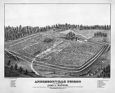 Andersonville National Historic Site |
October 16, 1970 (#70000070) |
1 mi. E of Andersonville on GA 49 32°12′23″N 84°07′24″W / 32.206389°N 84.123333°W |
Andersonville | National Historic Site |
| 3 | Ashby Street Shotgun Row Historic District |  Ashby Street Shotgun Row Historic District |
June 27, 1997 (#97000620) |
207, 209, and 211 Ashby St. 32°04′38″N 84°13′39″W / 32.077222°N 84.2275°W |
Americus | |
| 4 | Campbell Chapel AME Church | 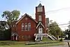 Campbell Chapel AME Church |
September 30, 1997 (#97001195) |
429 N. Jackson St. 32°04′38″N 84°14′01″W / 32.0772°N 84.2336°W |
Americus | |
| 5 | Dismuke Storehouse | March 7, 1996 (#96000247) |
505 N. Lee St. 32°04′38″N 84°13′56″W / 32.077222°N 84.232222°W |
Americus | ||
| 6 | Guerry-Mitchell House | June 16, 1983 (#83000242) |
723 McGarrah St. 32°04′47″N 84°14′16″W / 32.079722°N 84.237778°W |
Americus | ||
| 7 | Jimmy Carter National Historic Site |  Jimmy Carter National Historic Site |
December 23, 1987 (#01000272) |
300 N. Bond St. 32°01′49″N 84°25′06″W / 32.0304°N 84.4182°W |
Plains | administered by the National Park Service |
| 8 | Liberty Hall | 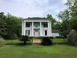 Liberty Hall |
November 25, 1980 (#80001236) |
SE of Americus on S. Lee St. 31°57′02″N 84°12′01″W / 31.95065°N 84.2003°W |
Americus | |
| 9 | Lustron House at 547 Oak Avenue | March 18, 1996 (#96000209) |
547 Oak Ave. 32°03′48″N 84°14′07″W / 32.063333°N 84.235278°W |
Americus | ||
| 10 | Newman McBain House | February 8, 1980 (#80001237) |
S of Americus on U.S. 19 32°02′33″N 84°15′13″W / 32.0425°N 84.253611°W |
Americus | ||
| 11 | Morgan Farm | February 26, 1998 (#98000145) |
770 Old Dawson Rd. 31°59′41″N 84°16′56″W / 31.994722°N 84.282222°W |
Smithville | ||
| 12 | New Corinth Baptist Church | August 10, 1998 (#98000928) |
1178 Hooks Mill Rd. 32°03′09″N 84°01′21″W / 32.0525°N 84.0225°W |
Americus | ||
| 13 | Plains Historic District | 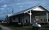 Plains Historic District |
June 28, 1984 (#84001220) |
Roughly bounded by Buena Vista Rd., Hospital, Clark, Main, Thomas, Paschal, and Bond Sts. 32°02′13″N 84°23′41″W / 32.036944°N 84.394722°W |
Plains | |
| 14 | Teel-Crawford-Gaston Plantation | October 27, 2004 (#04001188) |
2154 GA 30 W 32°08′40″N 84°23′43″W / 32.14444°N 84.39527°W |
Americus | ||
| 15 | Third District A & M School-Georgia Southwestern College Historic District | September 27, 2007 (#07001002) |
800 Wheatley St. 32°03′28″N 84°13′09″W / 32.0578°N 84.2191°W |
Americus | ||
| 16 | Webb Family Farm | 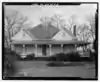 Webb Family Farm |
September 5, 1985 (#85001968) |
US 19 31°56′44″N 84°15′24″W / 31.94555°N 84.25678°W |
Sumter | Location of the main house - more to the south |
References
- ↑ National Park Service, United States Department of the Interior, "National Register of Historic Places: Weekly List Actions", retrieved December 22, 2023.
- ↑ Numbers represent an alphabetical ordering by significant words. Various colorings, defined here, differentiate National Historic Landmarks and historic districts from other NRHP buildings, structures, sites or objects.
- ↑ The eight-digit number below each date is the number assigned to each location in the National Register Information System database, which can be viewed by clicking the number.
Wikimedia Commons has media related to National Register of Historic Places in Sumter County, Georgia.
| Topics | |
|---|---|
| Lists by state |
|
| Lists by insular areas | |
| Lists by associated state | |
| Other areas | |
| Related | |
This article is issued from Wikipedia. The text is licensed under Creative Commons - Attribution - Sharealike. Additional terms may apply for the media files.