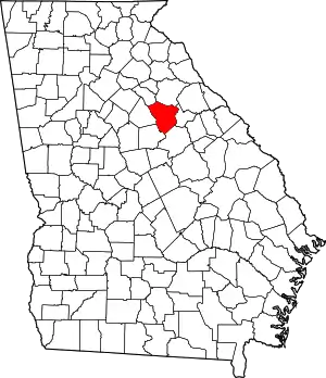
location of Greene County in Georgia
This is a list of properties and districts in Greene County, Georgia that are listed on the National Register of Historic Places (NRHP).
This National Park Service list is complete through NPS recent listings posted January 12, 2024.[1]

Current listings
| [2] | Name on the Register | Image | Date listed[3] | Location | City or town | Description |
|---|---|---|---|---|---|---|
| 1 | Dr. Calvin M. Baber House | 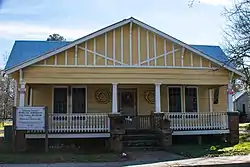 Dr. Calvin M. Baber House |
December 17, 1987 (#87001439) |
Penfield Rd. 33°35′04″N 83°10′26″W / 33.584444°N 83.173889°W |
Greensboro | |
| 2 | Bethesda Baptist Church and Cemetery | 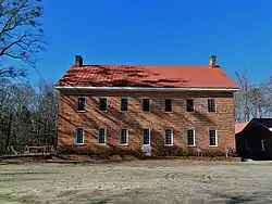 Bethesda Baptist Church and Cemetery |
August 6, 1998 (#98000967) |
Jct. of Cty Rd. 120 and Cty Rd. 129 33°39′07″N 83°00′36″W / 33.651944°N 83.01°W |
Union Point | |
| 3 | Brown-Bryson Farm | June 10, 1999 (#99000693) |
1760 Siloam-Veazey Rd. 33°31′43″N 83°06′11″W / 33.528611°N 83.103056°W |
Siloam | ||
| 4 | Church of the Redeemer |  Church of the Redeemer |
September 9, 1987 (#87001440) |
Jct. of Main and North Sts. 33°34′42″N 83°10′56″W / 33.578333°N 83.182222°W |
Greensboro | |
| 5 | Copeland Site (9GE18) | May 19, 1989 (#89000373) |
Address Restricted |
Greensboro | ||
| 6 | Early Hill Plantation | 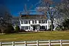 Early Hill Plantation |
June 13, 1997 (#97000559) |
Lickskillet Rd. 0.5 NE of US 278 33°35′18″N 83°13′00″W / 33.588333°N 83.216667°W |
Greensboro | |
| 7 | Greene County Courthouse |  Greene County Courthouse |
September 18, 1980 (#80001083) |
GA 12 33°34′36″N 83°10′56″W / 33.576667°N 83.182222°W |
Greensboro | |
| 8 | Greensboro Commercial Historic District | 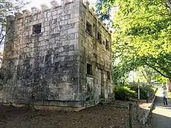 Greensboro Commercial Historic District |
November 6, 1987 (#87001438) |
Broad and Main Sts. 33°34′33″N 83°10′56″W / 33.575833°N 83.182222°W |
Greensboro | |
| 9 | Greensboro Depot | September 9, 1987 (#87001441) |
West St. 33°34′42″N 83°11′03″W / 33.578333°N 83.184167°W |
Greensboro | ||
| 10 | Jefferson Hall |  Jefferson Hall |
August 10, 1989 (#89001100) |
GA 12/U.S. Route 278 33°36′12″N 83°02′24″W / 33.60346°N 83.04002°W |
Union Point | |
| 11 | Mary Leila Cotton Mill and Village | 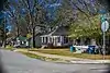 Mary Leila Cotton Mill and Village |
September 9, 1987 (#87001443) |
Roughly bounded by Cherry and Buffalo Sts. and Richland Ave., GA RR, Spring and Mill, and Mapple Sts. 33°34′47″N 83°11′14″W / 33.579722°N 83.187222°W |
Greensboro | |
| 12 | Moore-Crutchfield Place | April 12, 1990 (#90000549) |
GA 15, SE of Siloam 33°31′58″N 83°04′23″W / 33.532778°N 83.073056°W |
Siloam | ||
| 13 | North Street-East Street Historic District | North Street-East Street Historic District |
September 9, 1987 (#87001444) |
North, East, Greene, and Walnut Sts. 33°34′41″N 83°10′44″W / 33.578056°N 83.178889°W |
Greensboro | |
| 14 | Penfield Historic District | 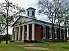 Penfield Historic District |
January 20, 1976 (#76000637) |
7 mi. N of Greensboro on GA 5925 33°40′07″N 83°10′11″W / 33.668611°N 83.169722°W |
Penfield | |
| 15 | Phillip Poullain House | September 9, 1987 (#87001448) |
Penfield Rd. 33°35′05″N 83°10′41″W / 33.584722°N 83.178056°W |
Greensboro | ||
| 16 | Peter W. Printup Plantation | September 5, 1985 (#85001977) |
GA 44 33°36′40″N 83°05′37″W / 33.611111°N 83.093611°W |
Union Point | ||
| 17 | Siloam Historic District | 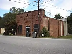 Siloam Historic District |
July 26, 2001 (#01000740) |
Roughly centered on Main St., Union Point Hwy., and Church St. 33°32′05″N 83°04′55″W / 33.534722°N 83.081944°W |
Siloam | |
| 18 | Siloam Junior High School | 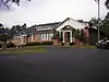 Siloam Junior High School |
February 20, 2002 (#02000036) |
473 GA 15S 33°31′55″N 83°04′34″W / 33.531944°N 83.076111°W |
Siloam | |
| 19 | South Street-Broad Street-Main Street-Laurel Street Historic District | September 9, 1987 (#87001450) |
South, Broad, Main, and Laurel Sts. 33°34′26″N 83°11′14″W / 33.573889°N 83.187222°W |
Greensboro | ||
| 20 | South Walnut Street Historic District | September 9, 1987 (#87001449) |
S. Walnut, E. South, and E. Broad Sts. 33°34′24″N 83°10′48″W / 33.573333°N 83.18°W |
Greensboro | ||
| 21 | Springfield Baptist Church |  Springfield Baptist Church |
September 9, 1987 (#87001451) |
Canaan Circle 33°34′39″N 83°10′41″W / 33.5775°N 83.178056°W |
Greensboro | |
| 22 | Union Manufacturing Company | February 24, 1989 (#89000026) |
500 Sibley Ave. 33°36′47″N 83°04′22″W / 33.613056°N 83.072778°W |
Union Point | ||
| 23 | Union Point Historic District | January 7, 1991 (#90002100) |
Roughly bounded by Lamb Ave., Washington Rd., Old Crawfordville Rd. and Hendry St. 33°37′01″N 83°04′27″W / 33.616944°N 83.074167°W |
Union Point | ||
| 24 | Woodville Baptist Church and School |  Woodville Baptist Church and School |
April 15, 1999 (#99000455) |
Jct. of E. Peachtree Ave. and Chestnut St. 33°40′14″N 83°06′00″W / 33.670556°N 83.1°W |
Woodville |
Former listings
| [2] | Name on the Register | Image | Date listed | Date removed | Location | City or town | Description |
|---|---|---|---|---|---|---|---|
| 1 | King-Knowles-Gheesling House | September 9, 1987 (#87001442) | February 6, 2020 | North St. 33°34′42″N 83°10′58″W / 33.578333°N 83.182778°W |
Greensboro |
References
- ↑ National Park Service, United States Department of the Interior, "National Register of Historic Places: Weekly List Actions", retrieved January 12, 2024.
- 1 2 Numbers represent an alphabetical ordering by significant words. Various colorings, defined here, differentiate National Historic Landmarks and historic districts from other NRHP buildings, structures, sites or objects.
- ↑ The eight-digit number below each date is the number assigned to each location in the National Register Information System database, which can be viewed by clicking the number.
Wikimedia Commons has media related to National Register of Historic Places in Greene County, Georgia.
| Topics | |
|---|---|
| Lists by state |
|
| Lists by insular areas | |
| Lists by associated state | |
| Other areas | |
| Related | |
This article is issued from Wikipedia. The text is licensed under Creative Commons - Attribution - Sharealike. Additional terms may apply for the media files.