Location of Leavenworth County in Kansas
This is a list of the National Register of Historic Places listings in Leavenworth County, Kansas.
This is intended to be a complete list of the properties and districts on the National Register of Historic Places in Leavenworth County, Kansas, United States. The locations of National Register properties and districts for which the latitude and longitude coordinates are included below, may be seen in a map.[1]
There are 47 properties and districts listed on the National Register in the county, including 2 National Historic Landmarks. Another property was once listed but has been removed.
This National Park Service list is complete through NPS recent listings posted January 5, 2024.[2]
Current listings
| [3] | Name on the Register[4] | Image | Date listed[5] | Location | City or town | Description |
|---|---|---|---|---|---|---|
| 1 | Abernathy Furniture Company Factory | 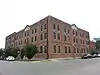 Abernathy Furniture Company Factory |
October 12, 2004 (#04001142) |
200-210 Seneca St.; also 100 N. 2nd St. 39°19′11″N 94°54′35″W / 39.319722°N 94.909722°W |
Leavenworth | Second set of addresses represent a boundary increase of April 5, 2016 |
| 2 | A.J. Angell House | .JPG.webp) A.J. Angell House |
November 17, 1977 (#77000586) |
714 S. Broadway 39°18′38″N 94°55′15″W / 39.310556°N 94.920833°W |
Leavenworth | |
| 3 | Arch Street Historic District | July 3, 2002 (#02000718) |
Roughly bounded by Arch, Pine, S. Second and S. Third Sts. 39°18′34″N 94°54′33″W / 39.309444°N 94.909167°W |
Leavenworth | ||
| 4 | Atchison, Topeka and Santa Fe Railroad Passenger Depot | .JPG.webp) Atchison, Topeka and Santa Fe Railroad Passenger Depot |
June 11, 1986 (#86001321) |
781 Shawnee St. 39°19′00″N 94°55′28″W / 39.316667°N 94.924444°W |
Leavenworth | |
| 5 | AXA Building | 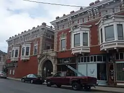 AXA Building |
March 17, 1972 (#72000509) |
205 S. 5th St. 39°19′04″N 94°54′54″W / 39.31772°N 94.91507°W |
Leavenworth | Late Victorian style commercial building, built in 1905. |
| 6 | Begley Bridge | 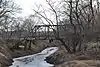 Begley Bridge |
May 9, 2003 (#03000373) |
Two unnamed farm roads flanking Stranger Creek, 1.1 miles west of junction with 227th St. and Roe Rd., 1.75 miles northwest of Millwood 39°24′39″N 95°07′25″W / 39.410833°N 95.123611°W |
Millwood | |
| 7 | David J. Brewer House | 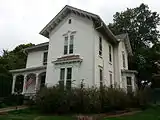 David J. Brewer House |
February 23, 1972 (#72000508) |
403 5th Ave. 39°18′22″N 94°55′02″W / 39.306111°N 94.917222°W |
Leavenworth | |
| 8 | Nathaniel H. Burt House | 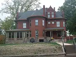 Nathaniel H. Burt House |
October 27, 1987 (#87001105) |
1200 5th Ave. 39°18′22″N 94°55′05″W / 39.306111°N 94.917917°W |
Leavenworth | |
| 9 | Caenen Site | September 6, 2005 (#05000973) |
Address restricted |
Tonganoxie | ||
| 10 | Edward Carroll House | 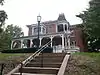 Edward Carroll House |
October 2, 1986 (#86002806) |
1128 5th Ave. 39°18′24″N 94°55′05″W / 39.306667°N 94.918056°W |
Leavenworth | |
| 11 | Delaware Cemetery | February 3, 2020 (#100004927) |
10388 222nd St. 38°57′49″N 95°05′37″W / 38.9636°N 95.0936°W |
Linwood | ||
| 12 | Evans Site | October 28, 2004 (#04001190) |
Address restricted |
Tonganoxie | ||
| 13 | First Presbyterian Church, Leavenworth | 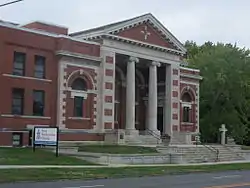 First Presbyterian Church, Leavenworth |
January 11, 2006 (#05001515) |
407 Walnut St. 39°18′49″N 94°54′47″W / 39.313611°N 94.913056°W |
Leavenworth | |
| 14 | Fort Leavenworth |  Fort Leavenworth |
October 15, 1966 (#66000346) |
Fort Leavenworth Military Reservation 39°21′11″N 94°55′01″W / 39.353056°N 94.916944°W |
Leavenworth | |
| 15 | Fort Leavenworth National Cemetery | 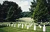 Fort Leavenworth National Cemetery |
July 15, 1999 (#99000834) |
Within Fort Leavenworth Military Reservation 39°21′05″N 94°55′48″W / 39.351389°N 94.93°W |
Fort Leavenworth | |
| 16 | Greenwood Cemetery | May 16, 2022 (#100007706) |
Tonganoxie Rd. and Limit St. 39°17′19″N 94°56′21″W / 39.2885°N 94.9393°W |
Leavenworth | ||
| 17 | Senator William A. Harris House | November 5, 1974 (#74000841) |
Northwest of Linwood on K-32 39°00′15″N 95°02′36″W / 39.004167°N 95.043333°W |
Linwood | ||
| 18 | Fred Harvey House | 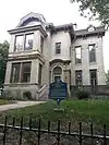 Fred Harvey House |
April 26, 1972 (#72000510) |
624 Olive St. 39°18′41″N 94°55′01″W / 39.311389°N 94.916944°W |
Leavenworth | |
| 19 | Helmers Manufacturing Company Building | 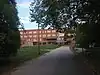 Helmers Manufacturing Company Building |
October 8, 2009 (#09000809) |
300 Santa Fe St./2500 2nd St. 39°17′32″N 94°54′25″W / 39.292356°N 94.906858°W |
Leavenworth | |
| 20 | Hollywood Theater | 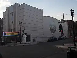 Hollywood Theater |
October 25, 1990 (#90001575) |
401 Delaware St. 39°19′05″N 94°54′54″W / 39.318056°N 94.915°W |
Leavenworth | |
| 21 | Alice and Edwin Holman Farmstead | April 7, 2023 (#100008785) |
26352 New Lawrence Dr. 39°15′05″N 94°57′23″W / 39.2515°N 94.9563°W |
Leavenworth | ||
| 22 | Hund School | 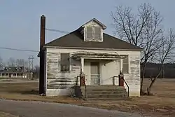 Hund School |
March 9, 2000 (#00000158) |
31874 179th St. 39°21′01″N 94°59′32″W / 39.3503°N 94.9922°W |
Leavenworth | |
| 23 | Merritt Insley House and Outbuildings | 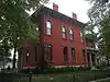 Merritt Insley House and Outbuildings |
October 2, 1986 (#86002801) |
602 Seneca St. 39°18′48″N 94°55′08″W / 39.3133°N 94.9189°W |
Leavenworth | |
| 24 | Horace and Rosemond Lamborn Farmstead | October 6, 2011 (#11000725) |
25761 151st. St. 39°14′27″N 94°55′56″W / 39.2408°N 94.9322°W |
Leavenworth | ||
| 25 | Lansing Man Archeological Site | March 24, 1971 (#71000316) |
Address restricted |
Lansing | ||
| 26 | Leavenworth County Courthouse | 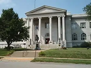 Leavenworth County Courthouse |
April 26, 2002 (#02000394) |
300 Walnut St. 39°18′19″N 94°54′43″W / 39.3053°N 94.9119°W |
Leavenworth | |
| 27 | Leavenworth Downtown Historic District | .JPG.webp) Leavenworth Downtown Historic District |
April 26, 2002 (#02000389) |
Roughly Cherokee St., Delaware St., S. Fifth St., and Shawnee St. 39°19′05″N 94°54′55″W / 39.3180°N 94.9154°W |
Leavenworth | |
| 28 | Leavenworth Historic Industrial District | April 29, 2002 (#02000406) |
Roughly Third St. Choctaw St., Second St. and Cherokee St. 39°19′00″N 94°54′36″W / 39.3167°N 94.91°W |
Leavenworth | ||
| 29 | Leavenworth Public Library | 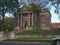 Leavenworth Public Library |
July 30, 1986 (#86002010) |
601 S. Fifth St. 39°18′48″N 94°54′55″W / 39.3133°N 94.9153°W |
Leavenworth | |
| 30 | Leavenworth Terminal Railway & Bridge Company Freight Depot | 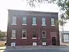 Leavenworth Terminal Railway & Bridge Company Freight Depot |
May 6, 2009 (#09000274) |
306 S. 7th St. 39°18′59″N 94°55′06″W / 39.3165°N 94.9182°W |
Leavenworth | |
| 31 | Little Stranger Church and Cemetery | 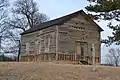 Little Stranger Church and Cemetery |
January 7, 2015 (#14001120) |
Northeastern corner of Tonganoxie and Stranger Rds. 39°14′43″N 94°58′26″W / 39.2452°N 94.974°W |
Leavenworth | |
| 32 | North Broadway Historic District | July 3, 2002 (#02000719) |
Along N. Broadway between Seneca and Ottawa Sts. 39°19′15″N 94°55′18″W / 39.3208°N 94.9217°W |
Leavenworth | ||
| 33 | North Broadway School | 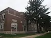 North Broadway School |
October 6, 2011 (#11000726) |
801 N. Broadway St. 39°19′29″N 94°55′24″W / 39.3247°N 94.9233°W |
Leavenworth | |
| 34 | North Esplanade Historic District | December 12, 1977 (#77000587) |
203-515 N. Esplanade 39°19′20″N 94°54′36″W / 39.3222°N 94.91°W |
Leavenworth | ||
| 35 | Old Union Depot | 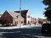 Old Union Depot |
March 11, 1982 (#82002663) |
201 S. Main St. 39°19′07″N 94°54′33″W / 39.3186°N 94.9092°W |
Leavenworth | Former Union Station, currently the Leavenworth Riverfront Community Center |
| 36 | Paul Site | September 6, 2005 (#05000977) |
Address restricted |
Tonganoxie | ||
| 37 | David W. Powers House | 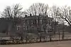 David W. Powers House |
August 30, 1977 (#77000588) |
2 miles northwest of Leavenworth off U.S. Route 73 39°21′00″N 94°57′44″W / 39.35°N 94.9622°W |
Leavenworth | |
| 38 | Quarry Creek Archeological Site | April 23, 1973 (#73000761) |
Northern side of McPherson Avenue immediately west of Sylvan Trail[6]: 122 39°21′38″N 94°55′36″W / 39.3606°N 94.9267°W |
Leavenworth | Along with the McPherson Site on the other side of McPherson Avenue, the largest Kansas City Hopewell site in the Leavenworth area[6]: 121 | |
| 39 | Scott Site | October 29, 2004 (#04001189) |
Address restricted |
Tonganoxie | ||
| 40 | William Small Memorial Home for Aged Women | September 23, 2020 (#100005624) |
711 North Broadway St. 39°19′26″N 94°55′21″W / 39.3238°N 94.9226°W |
Leavenworth | ||
| 41 | South Esplanade Historic District | July 3, 2002 (#02000720) |
Roughly bounded by Arch, Olive and S. Second Sts. and railroad 39°18′38″N 94°54′26″W / 39.3106°N 94.9072°W |
Leavenworth | ||
| 42 | Stonehaven Farm | June 29, 2018 (#100002626) |
19801 Tonganoxie Dr. 39°07′56″N 95°03′29″W / 39.1323°N 95.0581°W |
Tonganoxie | ||
| 43 | Sumner Elementary School | August 4, 2011 (#11000504) |
1501 5th Ave. 39°18′10″N 94°55′01″W / 39.3028°N 94.9169°W |
Leavenworth | ||
| 44 | Third Avenue Historic District | July 3, 2002 (#02000721) |
Roughly bounded by 2nd and Aves. and Congress and Middle Sts. 39°18′27″N 94°54′53″W / 39.3075°N 94.9147°W |
Leavenworth | ||
| 45 | Union Park Historic District | July 3, 2002 (#02000722) |
Roughly bounded by Chestnut, Congress, S. 6th, and W. 7th Sts. 39°18′39″N 94°55′00″W / 39.3108°N 94.9167°W |
Leavenworth | ||
| 46 | Western Branch, National Home for Disabled Volunteer Soldiers | 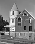 Western Branch, National Home for Disabled Volunteer Soldiers |
April 30, 1999 (#99000456) |
4101 S. 4th St. 39°16′43″N 94°53′29″W / 39.2786°N 94.8914°W |
Leavenworth | National Historic Landmark designation June 23, 2011 |
| 47 | Zacharias Site (14LV380) | January 8, 1987 (#86003517) |
Left bank of Salt Creek above its confluence with the Missouri River[7] 39°22′00″N 94°57′11″W / 39.3667°N 94.9531°W |
Leavenworth |
Former listing
| [3] | Name on the Register | Image | Date listed | Date removed | Location | City or town | Description |
|---|---|---|---|---|---|---|---|
| 1 | Biehler Barn | April 11, 1977 (#77000585) | February 22, 1979 | 2.5 miles north of Easton |
Easton | Destroyed by fire on December 22, 1978.[8] |
See also
Wikimedia Commons has media related to National Register of Historic Places in Leavenworth County, Kansas.
References
- ↑ The latitude and longitude information provided in this table was derived originally from the National Register Information System, which has been found to be fairly accurate for about 99% of listings. Some locations in this table may have been corrected to current GPS standards.
- ↑ National Park Service, United States Department of the Interior, "National Register of Historic Places: Weekly List Actions", retrieved January 5, 2024.
- 1 2 Numbers represent an alphabetical ordering by significant words. Various colorings, defined here, differentiate National Historic Landmarks and historic districts from other NRHP buildings, structures, sites or objects.
- ↑ "National Register Information System". National Register of Historic Places. National Park Service. March 13, 2009.
- ↑ The eight-digit number below each date is the number assigned to each location in the National Register Information System database, which can be viewed by clicking the number.
- 1 2 Logan, Brad. "West Side Story: Kansas City Hopewell and Steed-Kisker from a Trans-Missouri Perspective". Missouri Archaeologist 72 Whole Volume (2011): 114-160.
- ↑ Logan, Brad. "The Plains Village Frontier in the Kansas City Locality". Missouri Archaeologist 49 Whole Volume (1988): 3-25: 5
- ↑ https://www.kshs.org/publicat/history/1999spring_shortridge_round.pdf
| Topics | 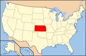 | |
|---|---|---|
| Lists by county |
| |
| Other lists |
| |
| ||
Municipalities and communities of Leavenworth County, Kansas, United States | ||
|---|---|---|
| Cities | Map of Kansas highlighting Leavenworth County | |
| Unincorporated communities | ||
| Ghost town | ||
| Townships |
| |
| Footnotes | ‡This community also has portions in an adjacent county or counties. | |
This article is issued from Wikipedia. The text is licensed under Creative Commons - Attribution - Sharealike. Additional terms may apply for the media files.