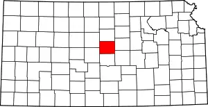
Location of Ellsworth County in Kansas
This is a list of the National Register of Historic Places listings in Ellsworth County, Kansas.
This is intended to be a complete list of the properties and districts on the National Register of Historic Places in Ellsworth County, Kansas, United States. The locations of National Register properties and districts, for which the latitude and longitude coordinates are included below, may be seen in a map.[1]
There are 22 properties and districts listed on the National Register in the county.
This National Park Service list is complete through NPS recent listings posted January 5, 2024.[2]
Current listings
| [3] | Name on the Register[4] | Image | Date listed[5] | Location | City or town | Description |
|---|---|---|---|---|---|---|
| 1 | Archeological Site Number 14EW14 | July 9, 1982 (#82004861) |
Address restricted [6] |
Carneiro | ||
| 2 | Archeological Site Number 14EW17 | July 9, 1982 (#82004874) |
Address restricted |
Ellsworth | ||
| 3 | Archeological Site Number 14EW33 | July 9, 1982 (#82004862) |
Address restricted |
Carneiro | ||
| 4 | Archeological Site Number 14EW303 | July 9, 1982 (#82004875) |
Address restricted |
Ellsworth | ||
| 5 | Archeological Site Number 14EW401 | July 9, 1982 (#82004876) |
Address restricted |
Ellsworth | ||
| 6 | Archeological Site Number 14EW403 | July 9, 1982 (#82004877) |
Address restricted |
Carneiro | ||
| 7 | Archeological Site Number 14EW404 | July 9, 1982 (#82004878) |
Address restricted |
Ellsworth | ||
| 8 | Archeological Site Number 14EW405 | July 9, 1982 (#82004863) |
Address restricted |
Geneseo | ||
| 9 | Archeological Site Number 14EW406 | July 9, 1982 (#82004879) |
Address restricted |
Ellsworth | ||
| 10 | Ellsworth Downtown Historic District | 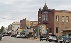 Ellsworth Downtown Historic District |
October 10, 2007 (#07001065) |
Generally including blocks between N. Main & 3rd Sts. from Lincoln to Kansas Aves. and the west side of Kansas Ave. 38°43′48″N 98°13′50″W / 38.729964°N 98.230447°W |
Ellsworth | |
| 11 | Fort Harker Guardhouse | 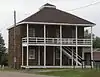 Fort Harker Guardhouse |
February 23, 1972 (#72000497) |
Northwestern corner of Wyoming and Ohio Sts., Fort Harker site 38°42′37″N 98°09′41″W / 38.71035°N 98.16141°W |
Kanopolis | Included in Fort Harker Museum |
| 12 | Fort Harker Officers' Quarters | 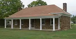 Fort Harker Officers' Quarters |
November 20, 1974 (#74000834) |
Ohio St. between Kansas and Colorado Sts., Fort Harker site 38°42′38″N 98°09′32″W / 38.71054°N 98.15894°W |
Kanopolis | Included in Fort Harker Museum. |
| 13 | Perry Hodgden House | 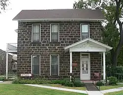 Perry Hodgden House |
January 29, 1973 (#73000754) |
104 W. Main St. 38°43′42″N 98°13′58″W / 38.728244°N 98.232762°W |
Ellsworth | |
| 14 | Holyrood Santa Fe Depot | 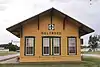 Holyrood Santa Fe Depot |
May 17, 2010 (#10000262) |
Between Main St and Smith St. 38°35′16″N 98°24′39″W / 38.587889°N 98.410719°W |
Holyrood | |
| 15 | Indian Hill Site | December 31, 1974 (#74000835) |
Southeastern quarter of the southeastern quarter of Section 28, Township 16 South, Range 6 West[6] 38°37′35″N 97°58′55″W / 38.626389°N 97.981944°W |
Marquette | ||
| 16 | Insurance Building | _from_NW_1.JPG.webp) Insurance Building |
July 11, 2006 (#06000595) |
115 N. Douglas Ave. 38°43′45″N 98°13′52″W / 38.729142°N 98.231083°W |
Ellsworth | |
| 17 | Arthur Larkin House | _from_N_1.JPG.webp) Arthur Larkin House |
February 24, 1975 (#75000712) |
0.25 mile south of Ellsworth off K-45 38°43′20″N 98°14′14″W / 38.722264°N 98.237255°W |
Ellsworth | |
| 18 | Ira E Lloyd Stock Farm | 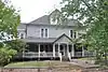 Ira E Lloyd Stock Farm |
January 7, 2015 (#14001118) |
1575 Ave. JJ 38°43′58″N 98°12′34″W / 38.7328°N 98.2094°W |
Ellsworth | |
| 19 | Midland Hotel | 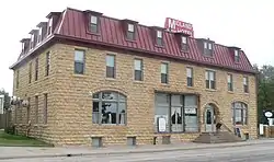 Midland Hotel |
July 3, 2002 (#02000716) |
414 26th St.[7] 38°49′32″N 98°28′23″W / 38.825571°N 98.47315°W |
Wilson | |
| 20 | Weinhold House | _from_W_1.JPG.webp) Weinhold House |
March 2, 2001 (#01000185) |
2315 C Ave. 38°49′39″N 98°28′14″W / 38.827436°N 98.470592°W |
Wilson | |
| 21 | Wilson Downtown Historic District #1-Main St. | 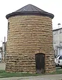 Wilson Downtown Historic District #1-Main St. |
July 15, 1998 (#03001496) |
Roughly along Main St., 24th St., 25th St., and 26th St. 38°49′36″N 98°28′25″W / 38.8266°N 98.4736°W |
Wilson | |
| 22 | Wilson Downtown Historic District #3-Southside | _and_Zeman_buildings_from_N_1.JPG.webp) Wilson Downtown Historic District #3-Southside |
January 28, 2004 (#03001497) |
400 block of 27th St., "Old Highway 40" 38°49′27″N 98°28′25″W / 38.824238°N 98.473748°W |
Wilson |
See also
Wikimedia Commons has media related to National Register of Historic Places in Ellsworth County, Kansas.
References
- ↑ The latitude and longitude information provided in this table was derived originally from the National Register Information System, which has been found to be fairly accurate for about 99% of listings. Some locations in this table may have been corrected to current GPS standards.
- ↑ National Park Service, United States Department of the Interior, "National Register of Historic Places: Weekly List Actions", retrieved January 5, 2024.
- ↑ Numbers represent an alphabetical ordering by significant words. Various colorings, defined here, differentiate National Historic Landmarks and historic districts from other NRHP buildings, structures, sites or objects.
- ↑ "National Register Information System". National Register of Historic Places. National Park Service. March 13, 2009.
- ↑ The eight-digit number below each date is the number assigned to each location in the National Register Information System database, which can be viewed by clicking the number.
- 1 2 Logan, Brad, ed. "Archaeological Investigations at Kanopolis Lake, Kansas: National Register Evaluation of 14EW3, 14EW6, 14EW19 and Shoreline Survey". University of Kansas Museum of Anthropology Project Report Series #100. Lawrence: U of Kansas, 1998-04, 2.
- ↑ "Contact Us". Midland Railroad Hotel. Retrieved 2014-09-27.
| Topics | 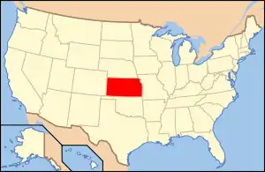 | |
|---|---|---|
| Lists by county |
| |
| Other lists |
| |
| ||
Municipalities and communities of Ellsworth County, Kansas, United States | ||
|---|---|---|
| Cities | Map of Kansas highlighting Ellsworth County | |
| Unincorporated communities | ||
| Ghost towns | ||
| Townships | ||
| Point of interest | ||
This article is issued from Wikipedia. The text is licensed under Creative Commons - Attribution - Sharealike. Additional terms may apply for the media files.