
This is a list of the National Register of Historic Places listings in Brown County, Indiana.
This is intended to be a complete list of the properties and districts on the National Register of Historic Places in Brown County, Indiana, United States. Latitude and longitude coordinates are provided for many National Register properties and districts; these locations may be seen together in a map.[1]
There are 9 properties and districts listed on the National Register in the county. Another 3 properties were once listed but have been removed.
Properties and districts located in incorporated areas display the name of the municipality, while properties and districts in unincorporated areas display the name of their civil township. Properties and districts split between multiple jurisdictions display the names of all jurisdictions.
This National Park Service list is complete through NPS recent listings posted January 12, 2024.[2]
Current listings
| [3] | Name on the Register[4] | Image | Date listed[5] | Location | City or town | Description |
|---|---|---|---|---|---|---|
| 1 | Bean Blossom Covered Bridge | 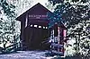 Bean Blossom Covered Bridge |
February 10, 2022 (#100007441) |
Covered Bridge Rd. over Bean Blossom Cr., 7/10 mi. SW of jct. of IN 45 and IN 135 39°15′39″N 86°15′19″W / 39.2609°N 86.2552°W |
Bean Blossom vicinity | |
| 2 | Brown County Bridge No. 36 | 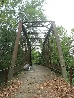 Brown County Bridge No. 36 |
December 21, 1993 (#93001430) |
Hickory Hill Rd. across the North Fork of Salt Creek, southwest of Nashville 39°10′59″N 86°18′12″W / 39.1831°N 86.3033°W |
Washington Township | |
| 3 | Brown County Courthouse Historic District | 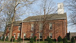 Brown County Courthouse Historic District |
July 21, 1983 (#83000050) |
Courthouse, Old Log Jail, and the Historical Society Museum Building 39°12′28″N 86°14′48″W / 39.2078°N 86.2467°W |
Nashville | |
| 4 | Brown County State Park | 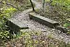 Brown County State Park |
December 7, 2020 (#100005867) |
1405 IN 46 West 39°06′49″N 86°15′53″W / 39.1136°N 86.2647°W |
Nashville vicinity | |
| 5 | Thomas A. Hendricks House and Stone Head Road Marker | 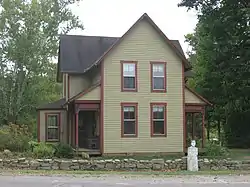 Thomas A. Hendricks House and Stone Head Road Marker |
December 6, 1984 (#84000450) |
State Road 135 and Bellsville Rd. at Stone Head 39°07′47″N 86°09′31″W / 39.1297°N 86.1586°W |
Van Buren Township | |
| 6 | Nashville Historic District | November 21, 2022 (#100008408) |
Roughly bounded by Old School Way, Johnson, Mound, and Franklin Sts. including blk. south of Franklin St. between Van Buren and Jefferson Sts. 39°12′26″N 86°14′54″W / 39.2072°N 86.2483°W |
Nashville | ||
| 7 | Theodore Clement Steele House and Studio | 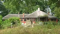 Theodore Clement Steele House and Studio |
October 2, 1973 (#73000029) |
Southwest of Nashville off State Road 46 39°07′50″N 86°20′19″W / 39.1306°N 86.3386°W |
Washington Township | Associated with American Impressionist painter T. C. Steele |
| 8 | Story Historic District | March 11, 2019 (#100003500) |
Elkinsville Rd. at IN 135 39°05′56″N 86°12′50″W / 39.0989°N 86.2138°W |
Nashville | ||
| 9 | F.P. Taggart Store | 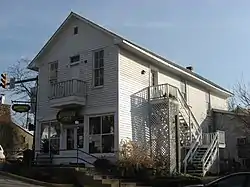 F.P. Taggart Store |
December 22, 1983 (#83003559) |
Main and Van Buren Sts. 39°12′25″N 86°14′52″W / 39.2069°N 86.2478°W |
Nashville |
Former listings
| [3] | Name on the Register | Image | Date listed | Date removed | Location | City or town | Description |
|---|---|---|---|---|---|---|---|
| 1 | Axsom Branch Archeological Site (12BR12) | March 25, 1986 (#86000525) | September 8, 1995 | Address Restricted |
Nashville | ||
| 2 | Grandview Church | 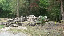 Grandview Church |
September 13, 1991 (#91001160) | September 29, 2010 | Grandview Ridge Rd. southeast of New Bellsville 39°07′28″N 86°04′05″W / 39.1244°N 86.0681°W |
Nashville | Destroyed by arsonist in 2010.[6] Pre-arson photograph. |
| 3 | Refuge No. 7 Archeological Site (12BR11) | March 25, 1986 (#86000629) | September 8, 1995 | Address Restricted |
Nashville |
See also
References
- ↑ The latitude and longitude information provided in this table was derived originally from the National Register Information System, which has been found to be fairly accurate for about 99% of listings. Some locations in this table may have been corrected to current GPS standards.
- ↑ National Park Service, United States Department of the Interior, "National Register of Historic Places: Weekly List Actions", retrieved January 12, 2024.
- 1 2 Numbers represent an alphabetical ordering by significant words. Various colorings, defined here, differentiate National Historic Landmarks and historic districts from other NRHP buildings, structures, sites or objects.
- ↑ "National Register Information System". National Register of Historic Places. National Park Service. March 13, 2009.
- ↑ The eight-digit number below each date is the number assigned to each location in the National Register Information System database, which can be viewed by clicking the number.
- ↑ 7th suspect arrested in Grandview Church Fire, WISH, 2010-07-24. Accessed 2010-10-08.
| Topics | |
|---|---|
| Lists by state |
|
| Lists by insular areas | |
| Lists by associated state | |
| Other areas | |
| Related | |

Municipalities and communities of Brown County, Indiana, United States | ||
|---|---|---|
| Town | Map of Indiana highlighting Brown County | |
| Townships | ||
| CDPs | ||
| Other communities | ||
| Footnotes | ‡This populated place also has portions in an adjacent county or counties | |