This is a list of properties and districts in Carroll County, Georgia that are listed on the National Register of Historic Places (NRHP).
This National Park Service list is complete through NPS recent listings posted January 12, 2024.[1]

Current listings
| [2] | Name on the Register | Image | Date listed[3] | Location | City or town | Description |
|---|---|---|---|---|---|---|
| 1 | Bonner-Sharp-Gunn House | 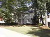 Bonner-Sharp-Gunn House |
May 13, 1970 (#70000198) |
University of West Georgia campus 33°34′17″N 85°05′53″W / 33.571389°N 85.098056°W |
Carrollton | |
| 2 | Bowdon Historic District | 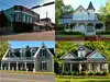 Bowdon Historic District |
December 8, 2009 (#09001056) |
Roughly centered along Georgia State Route 166 and Georgia State Route 100 33°32′17″N 85°15′12″W / 33.538189°N 85.253344°W |
Bowdon | |
| 3 | Burns Quarry |  Burns Quarry |
August 29, 1977 (#77001539) |
Address Restricted |
Carrollton | |
| 4 | Carroll County Courthouse | 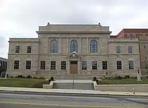 Carroll County Courthouse |
September 18, 1980 (#80000985) |
Newnan and Dixie Sts. 33°34′46″N 85°04′22″W / 33.579444°N 85.072778°W |
Carrollton | Built in 1928 |
| 5 | Carrollton Downtown Historic District | 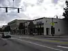 Carrollton Downtown Historic District |
May 1, 2007 (#07000378) |
Roughly around downtown sq. and is bounded by Johnson Ave., White St., Mill St. and Barnes St. 33°34′48″N 85°04′26″W / 33.580031°N 85.073878°W |
Carrollton | |
| 6 | Dorough Round Barn and Farm | 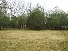 Dorough Round Barn and Farm |
January 20, 1980 (#80000986) |
N of Hickory Level on Villa Rica Rd. 33°41′07″N 84°59′18″W / 33.685278°N 84.988333°W |
Hickory Level | |
| 7 | Eric Vernon Folds House | 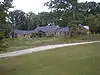 Eric Vernon Folds House |
August 24, 2005 (#05000902) |
1575 GA 16 33°38′10″N 85°02′16″W / 33.636111°N 85.037778°W |
Carrollton | |
| 8 | Lawler Hosiery Mill |  Lawler Hosiery Mill |
January 26, 2005 (#04001558) |
301 Bradley St. 33°34′40″N 85°04′34″W / 33.577778°N 85.076111°W |
Carrollton | |
| 9 | Dr. James L. Lovvorn House | .JPG.webp) Dr. James L. Lovvorn House |
May 19, 1988 (#88000595) |
113 E. College St. 33°32′18″N 85°15′11″W / 33.538333°N 85.253056°W |
Bowdon | |
| 10 | Mandeville Mills and Mill Village Historic District | 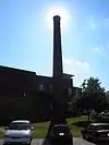 Mandeville Mills and Mill Village Historic District |
April 19, 2006 (#06000287) |
Roughly centered on Aycock, Lovvorn, and Burson Sts. 33°34′46″N 85°05′19″W / 33.579444°N 85.088611°W |
Carrollton | |
| 11 | McDaniel-Huie Place | .JPG.webp) McDaniel-Huie Place |
May 24, 1990 (#90000803) |
1238 SR 166 W. 33°32′36″N 85°16′35″W / 33.543333°N 85.276389°W |
Bowdon | |
| 12 | North Villa Rica Commercial Historic District | 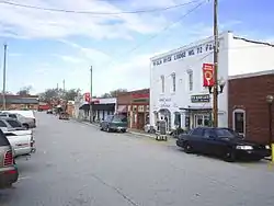 North Villa Rica Commercial Historic District |
December 31, 2002 (#02001635) |
Roughly bounded by Southern Railroad, North Ave., and East Gordon and West Church Sts. 33°43′56″N 84°55′30″W / 33.732222°N 84.925°W |
Villa Rica | |
| 13 | South Carrollton Residential Historic District | .JPG.webp) South Carrollton Residential Historic District |
June 28, 1984 (#84000947) |
Roughly bounded by RR tracks, Harmon and West Aves., Bradley, Mill and Garrett Sts., Tillman and Hill Drs. 33°34′32″N 85°04′20″W / 33.575556°N 85.072222°W |
Carrollton | |
| 14 | U.S. Post Office | 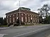 U.S. Post Office |
April 18, 1983 (#83000185) |
402 Newnan St. 33°34′48″N 85°04′21″W / 33.58°N 85.0725°W |
Carrollton | |
| 15 | Veal School | Veal School |
December 22, 2005 (#05001427) |
2753 Old Columbus Rd. 33°26′08″N 85°13′55″W / 33.435556°N 85.231944°W |
Roopville | |
| 16 | Whitesburg Baptist Church | 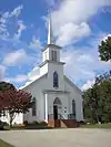 Whitesburg Baptist Church |
October 22, 2002 (#02001220) |
662 Main St. 33°29′35″N 84°54′50″W / 33.493056°N 84.913889°W |
Whitesburg | |
| 17 | Williams Family Farm | 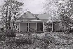 Williams Family Farm |
March 25, 2005 (#05000193) |
55 Goldworth Rd. 33°42′12″N 84°56′36″W / 33.703333°N 84.943333°W |
Villa Rica |
References
- ↑ National Park Service, United States Department of the Interior, "National Register of Historic Places: Weekly List Actions", retrieved January 12, 2024.
- ↑ Numbers represent an alphabetical ordering by significant words. Various colorings, defined here, differentiate National Historic Landmarks and historic districts from other NRHP buildings, structures, sites or objects.
- ↑ The eight-digit number below each date is the number assigned to each location in the National Register Information System database, which can be viewed by clicking the number.
Wikimedia Commons has media related to National Register of Historic Places in Carroll County, Georgia.
This article is issued from Wikipedia. The text is licensed under Creative Commons - Attribution - Sharealike. Additional terms may apply for the media files.