| Mola de Colldejou | |
|---|---|
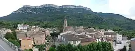 North face of Mola de Colldejou rising above La Torre de Fontaubella | |
| Highest point | |
| Elevation | 921.8 m (3,024 ft) |
| Prominence | 377 m (1,237 ft) |
| Isolation | 17.39 km (10.81 mi) to Puig de Gallicant |
| Coordinates | 41°6′32.08″N 0°52′26.43″E / 41.1089111°N 0.8740083°E |
| Geography | |
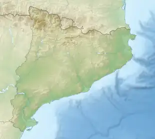 Mola de Colldejou Catalonia, Spain | |
| Location | Baix Camp & Priorat, (Catalonia) |
| Parent range | Catalan Pre-Coastal Range |
| Geology | |
| Mountain type | Karstic |
| Climbing | |
| First ascent | Unknown |
| Easiest route | From Colldejou or La Torre de Fontaubella |
Mola de Colldejou is a mountain chain in Catalonia, Spain located north of the Serra de Llaberia in the Catalan Pre-Coastal Range. The highest point is 921.8 m above sea level.[1]
This mountain range is named after Colldejou village, located east of the range.
See also
References
External links
Wikimedia Commons has media related to Mola de Colldejou.
This article is issued from Wikipedia. The text is licensed under Creative Commons - Attribution - Sharealike. Additional terms may apply for the media files.