Public roads in Hungary are ranked according to importance and traffic as follows:
- controlled-access highway (gyorsforgalmi út – pl. gyorsforgalmi utak) – colour: blue; designation: M followed by one or two digits. It has two categories: motorways and expressways.
- motorways (autópálya – pl. autópályák): 2+2 travel lanes and emergency lane, central reservation, no at-grade intersections
- expressway (autóút – pl. autóutak): mostly 2+2 travel lanes without emergeny line, central reservation, some at-grade intersections
- main roads (főút – pl. főutak) – colour: green; designation: one, two or three digits
- primary main roads (elsődrendű főút – pl. elsőrendű főutak): national importance roads
- secondary main roads (másodrendű főút – pl. másodrendű főutak): regional importance roads
- side roads (mellékút - pl. mellékutak) – colour: green; designation: with four or five digits
- municipal roads (önkormányzati út- pl. önkormányzati utak)
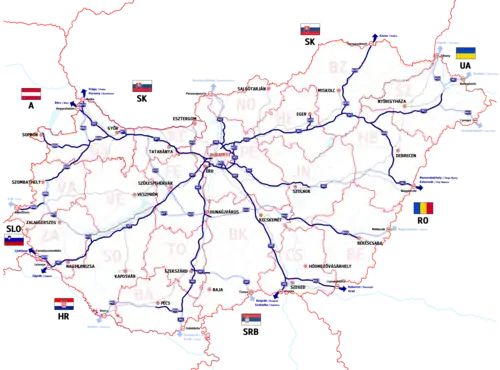
Some of the national roads are part of the European route scheme.
European routes passing through Hungary: E60; E65; E66; E68; E71; E73; E75; E77; E79 (Class A); E573; E653; E661 (Class B).
Highways

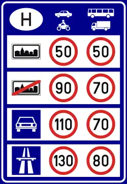
They have one lane in each direction, signs are white-on-blue and the normal speed limit is 130 km/h, in expressways 110 km/h. According to the Állami Autópályakezelő Zrt. ("State Motorway Management Plc."), the total length of the Hungarian motorway system was 1,400.6 kilometers in 2013.[1] The construction of the Hungarian motorway system started in 1964 with M7, which finished in 1975 between Budapest and Lake Balaton. The total length of the system reached 200 km in 1980, 500 km in 1998, and 1000 km in 2007.
Road signs are white shield on blue and the abbreviation for both types of highways is M.
The main differences are that motorways feature emergency lanes and the maximum allowed speed limit is 130 km/h (81 mph), while expressways may be built without them and the speed limit is 110 km/h (68 mph).
- Motorways are public roads with controlled access which are designated for motor vehicles only, and feature two carriageways with at least two continuous lanes each with paved emergency lanes, divided by a median. They have no one-level intersections with any roads or other forms of land and water transport. They are equipped with roadside rest areas, which are intended only for the users of the motorway.
- Expressways share most of the characteristics of motorways, differing mainly in that:
- Expressways may be built without paved emergency lanes.
- Expressways are designated for lower speed than motorways. For example, the road curvature can be higher and the lanes are usually narrower (3.5 m vs 3.75 m).
- Expressways can have a single carriageway on sections with low traffic density.
Development of the overall length (at the end of):
| Year | 1965 | 1970 | 1975 | 1980 | 1985 | 1990 | 1995 | 2000 | 2005 | 2010 | 2015 | 2020 | dec 2023 |
| Length [km] | 7 | 85 | 132 | 213 | 302 | 347 | 384 | 531 | 777 | 1,241 | 1,399 | 1,745 | 1,880 |
List of highways
- Highways in service:
- Motorways:

![]() M1 |
M1 |
![]() M3 |
M3 |
![]() M4 |
M4 |
![]() M5 |
M5 |
![]() M6 |
M6 |
![]() M7 |
M7 |
![]() M8 |
M8 |
![]() M15 |
M15 |
![]() M30 |
M30 |
![]() M31 |
M31 |
![]() M35 |
M35 |
![]() M43 |
M43 |
![]() M60 |
M60 |
![]() M70
M70
- Expressways:
![]() M0 |
M0 |
![]() M2 |
M2 |
![]() M4 |
M4 |
![]() M9 |
M9 |
![]() M19 |
M19 |
![]() M25 |
M25 |
![]() M44 |
M44 |
![]() M49 |
M49 |
![]() M51 |
M51 |
![]() M76 |
M76 |
![]() M85 |
M85 |
![]() M86
M86
- Proposed Highways:
M10 | M32 | M34 | M71 | M87 | M100 | M200
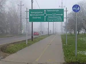
Main roads


_-_panoramio_(2).jpg.webp)
.jpg.webp)
.JPG.webp)
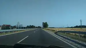
They have one lane in each direction, signs are white-on-green and the normal speed limit is 90 km/h.
Primary main roads
Roads categorized as state roads, primary main roads are 2,169 km in total length as of December 2022.[2] The routes are marked with one, two, or three-digit numbers.
Secondary main road
Roads categorized as state roads, class IIb are 4,849 km in total length as of December 2022.[2] The routes are marked with two or three-digit numbers.
| Designation | Route | Length | |
|---|---|---|---|
| Hegyeshalom (Main road 1) - M1 motorway | 1 km | ||
| Herceghalom (Main road 1) - Zsámbék - Pilisjászfalu (Main road 10) | 23 km | ||
| Óbuda (Main road 10) - Szentendre - Esztergom - Main road 117 | 72 km | ||
| Esztergom (Main road 11) - Dorog (Main road 10) | 8 km | ||
| Bypass of Dorog | 16 km | ||
| Vác (M2 epressway) - Nagymaros - Szob | 27 km | ||
| Border with Slovakia |
29 km | ||
| 132 | Old Komárom section of Main road 13 (Border with Slovakia |
4 km | |
| Győr (Main road 81) - Vámosszabadi / Border with Slovakia |
13 km | ||
| Old Salgótarján section of Main road 21 | 3 km | ||
| Rétság (Main road 2) - Balassagyarmat - Szécsény - Salgótarján (Main road 21) Old section of Main road 2 |
67 km | ||
| Balassagyarmat (Main road 22) / Border with Slovakia |
2 km | ||
| Bátonyterenye (Main road 21) - Pétervására - Tarnalelesz (Main road 25) | 33 km | ||
| Gyöngyös (Main road 3) - Recsk - Sirok - Eger (Main road 25) | 60 km | ||
| Kerecsend (Main road 3) - Eger - Tarnalelesz - Ózd - Bánréve (Main road 26) | 82 km | ||
| 251 | Maklár (M25 expressway) - Füzesabony (Main road 3) | 4 km | |
| Part of the southern bypass of Eger (Main road 25 - M25 expressway) | 1 km | ||
| Mezőkövesd (Main road 3) - Andornaktálya (M25 expressway) Old section of Side road 2502 |
12 km | ||
| Miskolc (Main road 3) - Kazincbarcika - Putnok - Bánréve / Border with Slovakia |
45 km | ||
| 260 | Bypass of Sajószentpéter and Berente | 11 km | |
| Sajószentpéter (Main road 26) - Edelény - Szendrő - Tornanádaska / Border with Slovakia | 55 km | ||
| Emőd (Main road 3) - M3 motorway | 8 km | ||
| Southern bypass of Miskolc (Main road 3 - M30 motorway) | 4 km | ||
| Northern bypass of Miskolc (M30 motorway - Main road 26) | 6 km | ||
| Budapest - Gyömrő - Nagykáta - Jászberény - Jászapáti - Heves - Füzesabony (Main road 33) | 126 km | ||
| Nagykáta (Main road 31) - Farmos - Cegléd (Main road 4) | 34 km | ||
| Hatvan (M3 motorway) - Jászberény - Újszász - Szolnok (Main road 4) | 80 km | ||
| Füzesabony (Main road 3) - Tiszafüred - Hortobágy - Debrecen (Main road 4) | 111 km | ||
| Western bypass of Mezőkövesd (Main road 3 - M30 motorway) | 6 km | ||
| Western bypass of Nyíregyháza (M3 motorway - Main road 38) | 7 km | ||
| Tiszafüred (Main road 33) - Kunmadaras - Kunhegyes - Fegyvernek (Main road 4) | 55 km | ||
| Nyékládháza (Main road 3) - Tiszaújváros - Polgár - Hajdúböszörmény - Debrecen (Main road 4) | 86 km | ||
| 351 | Introduction road of Tiszaújváros (Main road 35 - M3 motorway) | 8 km | |
| Polgár Main road Main road 35) - Tiszavasvári - Nyíregyháza (Main road 38) | 50 km | ||
| Felsőzsolca (Main road 3) - Szerencs - Sárospatak - Sátoraljaújhely / Border with Slovakia |
76 km | ||
| Tarcal (Main road Main road 37) - Tokaj - Rakamaz - Nyíregyháza (Main road 4) | 37 km | ||
| Sátoraljaújhely (Main road 37) - Cigánd - Kisvárda (Main road 4) | 47 km | ||
| Encs (Main road 3) - Abaújszántó - Mezőzombor (Main road 37) | 36 km | ||
| M4 expressway - Main road 4 near Abony | 1 km | ||
| Southern Introduction road of Szolnok (Main road 4 - Main road 32) | 6 km | ||
| 404 | Eastern bypass of Üllő (M4 expressway – Main road 4); Old section of Main road 4 | 2 km | |
| Abony (M4 expressway) – Szolnok (Main road 4-32) | 4 km | ||
| Berettyóújfalu Old section of Main road 42 |
3 km | ||
| Eastern bypass of Makó (M43 motorway - Main road 43) | 8 km | ||
| Kiszombor (Main road 43) / Border with Romania |
6 km | ||
| Cegléd (Main road 4) - Nagykőrös - Kecskemét (Main road 5) | 31 km | ||
| Szolnok (Main road 4) - Martfű - Kunszentmárton (Main road 44) | 43 km | ||
| Szarvas (Main road 44) - Gyomaendrőd (Main road 46) | 19 km | ||
| Western bypass and Southern Introduction road of Békéscsaba | 2 km | ||
| Northeastern bypass of Kecskemét (Main road 44 - Hetényegyháza) | 13 km | ||
| 446 | Old Békéscsaba section of Main road 44 | 2 km | |
| Kunszentmárton (Main road 44) - Szentes - Hódmezővásárhely (Main road 47) | 53 km | ||
| Szentes (Main road 45) - Csongrád - Kiskunfélegyháza (Main road 5) | 42 km | ||
| Törökszentmiklós (Main road 4) - Mezőtúr - Gyomaendrőd - Mezőberény (Main road 47) | 66 km | ||
| Debrecen (Main road 4) - Berettyóújfalu - Szeghalom - Mezőberény - Békéscsaba - Orosháza - Hódmezővásárhely - Szeged (Main road 5) | 215 km | ||
| Mezőberény (Main road 47) - Békés - Békéscsaba (Main road 446) Old section of Main road 47 |
21 km | ||
| Debrecen (Main road 4) - Nyíradony - Nyírbátor - Mátészalka (Main road 49) | 73 km | ||
| 472 | Old Hódmezővásárhely section of Main road 47 | 7 km | |
| Old Orosháza section of Main road 47 | 13 km | ||
| Debrecen (Main road 4) - Vámospércs - Nyírbátor / Border with Romania |
30 km | ||
| Southern bypass of Debrecen (Main road 47 - M35 motorway) | 6 km | ||
| Vaja (Main road 41) - Mátészalka - Csenger - Csengersima / Border with Romania |
57 km | ||
| Győrtelek (Main road 49) - Fehérgyarmat - Tiszabecs / Border with Ukraina | 20 km | ||
| Baktalórántháza (Main road 41) - Nyírbátor (Main road 471) | 20 km | ||
| Soroksár (M0 expressway) - Solt - Kalocsa - Baja - Hercegszántó / Border with Serbia |
191 km | ||
| Old Soroskár, Dunaharaszti and Taksony section of Main road 51 | 11 km | ||
| East bypass of Baja (Main road 51 - Main road 55) | 4 km | ||
| Western bypass of Kalocsa | 4 km | ||
| Old Dunavecse and Apostag section of Main road 51 | 8 km | ||
| Kecskemét (Main road 5) - Solt - Dunaföldvár (Main road 6) | 64 km | ||
| Solt (Main road 52) - Kiskőrös - Soltvadkert - Kiskunhalas - Tompa / Border with Serbia |
89 km | ||
| Kecskemét (Main roads 5-44) - Bugacpusztaháza - Soltvadkert - Sükösd (Main road 51) | 92 km | ||
| Southern Introduction road of Kecskemét (Main road 5 - Main road 54) | 4 km | ||
| Western bypass of Kiskunfélegyháza | 9 km | ||
| Szeged (Main road 5) - Mórahalom - Mélykút - Baja - Bátaszék (M6 motorway) | 122 km | ||
| Introduction road of Baja (Old section of Main Road 55) | 2 km | ||
| Szekszárd (Main road 6) - Bátaszék - Mohács - Udvar / Border with Croatia |
61 km | ||
| Pécs (Main road 6) - Bóly - Mohács | 38 km | ||
| Eastern bypass of Pécs (Main road 6 - M60 motorway) | 9 km | ||
| Pécs (Main road 6) - Harkány - Drávaszabolcs / Border with Croatia |
33 km | ||
| Sign | Number | Route | Length |
|---|---|---|---|
| 61 | Dunaföldvár - Cece - Simontornya - Tamási - Dombóvár - Kaposvár - Nagykanizsa (Intersection with Motorway M7) | 195 km | |
| 610 | Kaposvár (old section of Main road 61) | 16 km | |
| 611 | Dombóvár - Sásd | 14 km | |
| 62 | Dunaújváros (Intersection with Main road 6) - Seregélyes - Székesfehérvár | 47 km | |
| 63 | Szekszárd (Intersection with Main road 6) - Cece - Sárbogárd - Székesfehérvár (Intersection with Motorway M7) | 90 km | |
| 631 | Motorway M6 - Main road 63 | 5 km | |
| 64 | Simontornya - Enying (Intersection with Main road 7) | 37 km | |
| 65 | Szekszárd (Intersection with Main road 6) - Tamási - Siófok | 85 km | |
| 651 | Tamási bypass (Main road 65 - Main road 61) | 10 km | |
| 66 | Pécs - Sásd - Kaposvár (Intersection with Main roads 61 and 610) | 54 km | |
| 67 | Szigetvár - Kaposvár - Balatonlelle | 90 km | |
| 68 | Barcs - Nagyatád - Marcali - Balatonszentgyörgy (Intersection with Main roads 7 and 76) | 95 km | |
| 681 | Nagyatád (Intersection with Main road 68) - Border with Croatia |
24 km | |
| 682 | Marcali (old section of Main road 68) | 6 km | |
| 71 | Lepsény (Intersection with Main road 7) - Balatonfűzfő - Balatonalmádi - Balatonfüred - Balatonederics - Keszthely (Intersection with Main road 76) | 116 km | |
| 710 | Balatonakarattya (Intersection with Main road 71) - Balatonfűzfő (Intersection with Main road 72) | 17 km | |
| 72 | Balatonfűzfő - Litér - Veszprém (Intersection with Main road 8) | 7 km | |
| 73 | Csopak (Intersection with Main road 71) - Veszprém (Intersection with Main road 8) | 13 km | |
| 74 | Nagykanizsa (Intersection with Main road 7) - Bak - Zalaegerszeg - Vasvár (Intersection with Main road 8) | 75 km | |
| 75 | Keszthely (Intersection with Main road 71) - Pacsa - Bak - Rédics | 69 km | |
| 76 | Balatonszentgyörgy (Intersection with Main roads 7 and 68) - Sármellék - Zalaegerszeg - Nádasd (Intersection with Main road 86) | 82 km | |
| 760 | Main road 75 - Hévíz - Main road 76 | - km | |
| 761 | Zalaegerszeg north bypass (Main road 74 - Main road 76) | - km | |
| 762 | Zalaegerszeg (old section of Main road 76) | - km | |
| 77 | Veszprém (Intersection with Main road 71) - Nagyvázsony - Tapolca - Lesencetomaj (Intersection with Main road 84) | 54 km | |
| 81 | Székesfehérvár (Intersection with Main road 8) - Mór - Kisbér - Győr | 81 km | |
| 811 | Székesfehérvár - Lovasberény - Felcsút - Bicske (Intersection with Main road 1) | 42 km | |
| 813 | Győr northeast bypass (Intersection with Motorway M1 - Main road 14) | 13 km | |
| 82 | Veszprém (Intersection with Main road 8) - Zirc - Pannonhalma - Győr | 80 km | |
| 821 | Győr (Main road 83 - Main road 1) | 3 km | |
| 83 | Városlőd (Intersection with Main road 8) - Pápa - Tét - Győr | 76 km | |
| 830 | Veszprém north bypass (Main road 82 – Main road 8) | 7 km | |
| 832 | Pápa (Intersection with Main road 83) - Pápateszér - Veszprémvarsány (Intersection with Main road 82) | 30 km | |
| 834 | Pápa (Intersection with Main road 83) - Celldömölk - Sárvár-Hegyközség (Intersection with Main road 84) | 41 km | |
| 84 | Balatonederics (Intersection with Main road 71) - Sümeg - Sárvár - Hegyfalu - Border with Austria |
132 km | |
| 85 | Győr (Intersection with Main road 1) - Csorna - Kapuvár - Nagycenk (Intersection with Main road 84) | 72 km | |
| 86 | Mosonmagyaróvár - Csorna - Répcelak - Szombathely - Körmend - Zalalövő - Border with Slovenia |
159 km | |
| 861 | Border with Austria |
2 km | |
| 87 | Kám - Rum - Szombathely - Border with Austria |
49 km | |
| 88 | Sárvár (Intersection with Main road 84) - Vát (Intersection with Main road 86) | 12 km | |
| 89 | Szombathely (Intersection with Main road 87) - Torony - Border with Austria |
18 km | |
Local roads
Minor, local roads in the country are designated as "local roads". The total length of these roads is 23,780 km and are marked with four or some five-digit numbers, while the rest have consisted of macadam and earthen roads.
European routes
The following European routes pass through Hungary:
Class A
 E60: (France, Switzerland, Austria, Germany, Austria) – Hegyeshalom – Mosonmagyaróvár – Győr – Tatabánya – Budapest – Szolnok – Püspökladány – Ártánd – (Romania, Georgia, Azerbaijan, Turkmenistan, Uzbekistan, Tajikistan, Kyrgyzstan, China)[3]
 E65: (Sweden, Poland, Czech Republic, Slovakia) – Rajka – Csorna – Szombathely – Körmend – Zalaegerszeg – Nagykanizsa – Letenye – (Croatia, Bosnia and Herzegovina, Croatia, Montenegro, Kosovo, North Macedonia, Greece)
 E66: (Italy, Austria) – Rábafüzes – Körmend – Ajka – Veszprém – Székesfehérvár – Dunaújváros – Kecskemét – Cegléd
 E68: Szeged – Makó – Csanádpalota – (Romania)
 E71: (Slovakia) – Tornyosnémeti – Miskolc – Füzesabony – Hatvan – Budapest – Székesfehérvár – Siófok – Nagykanizsa – Letenye – (Croatia)
 E73: Budapest – Dunaújváros – Paks – Szekszárd – Mohács – Udvar – (Croatia, Bosnia and Herzegovina)
 E75: (Norway, Finland, Poland, Czech Republic, Slovakia) – Rajka – Győr – Tatabánya – Budapest – Kecskemét – Szeged – Röszke – (Serbia, North Macedonia, Greece)
 E77: (Russia, Estonia, Latvia, Lithuania, Russia, Poland, Slovakia) – Parassapuszta – Vác – Budapest
 E79: Miskolc – Polgár – Debrecen – Berettyóújfalu – Ártánd – (Romania, Bulgaria, Greece)
Class B
 E573: Püspökladány – Debrecen – Nyíregyháza – Záhony – (Ukraina)
 E575: (Slovakia) – Vámosszabadi – Győr
 E579: Görbeháza – Nyíregyháza – Vásárosnamény – Beregdaróc
 E653: (Slovenia) – Tornyiszentmiklós – Letenye
 E661: Balatonkeresztúr – Nagyatád – Barcs – (Croatia, Bosnia and Herzegovina)
See also
References
- ↑ Állami Autópályakezelő Zrt. (ÁAK) (2013). "Az ÁAK által kezelt úthálózat részletes adatai (2013)". Archived from the original on 2015-03-23. Retrieved 2015-05-14.
- 1 2 "Az állami közúthálózatról - Országos közúthálózat hossza 2005-2022". magyarkozut.hu. 2023-12-22. Retrieved 2023-12-22.
- ↑ "UNECE document ECE/TRANS/SC.1/2016/03/Rev1 "European Agreement On Main International Traffic Arteries (AGR)"" (PDF). The United Nations Economic Commission for Europe. 1 November 2016. Retrieved 16 May 2020.
| Highways |
| | ||||
|---|---|---|---|---|---|---|
| Main roads |
| |||||
Planned | ||||||