_Otszogletu_zold_tabla.svg.png.webp) | |
|---|---|
| 14-es főút | |
 | |
| Route information | |
| Part of | |
| Length | 12.5 km (7.8 mi) |
| Major junctions | |
| From | |
| |
| To | Vámosszabadi |
| Location | |
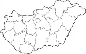
| Country | Hungary |
| Counties | Győr-Moson-Sopron |
| Major cities | Győr |
| Highway system | |
| |
The Main road 14 (Hungarian: 14-es főút) is a south–north direction Secondary class main road in the Kisalföld, that connects the Main road 1 change to the border of Slovakia. The road is 12.5 kilometres (7.8 mi) long.[1]
The road, as well as all other main roads in Hungary, is managed and maintained by Magyar Közút, state owned company.
Road junctions and populated areas
| Main road 14 junctions/populated areas/toll plazas | |
| Type | Slip roads/Notes |
| Győr, Árkád junction The southern terminus of the road. | |
| Győr, Schwarzenberg u. / Vas Gerben u. | |
| Széchenyi Bridge (Mosoni-Duna) | |
| Győr, Szövetség u. / Bárka u. Győr, Bácsai út Side road 1301 to Nagybajcs. Győr, Zemplén u. / Körtöltés u. | |
| MOL petrol station | |
| Győr, Újfalusi országút Side road 1401 to Győrújfalu and Mosonmagyaróvár. | |
| Győr-kelet | |
| Vámosszabadi Side road 1303 to Nagybajcs. | |
| Vámosszabadi border crossing to Slovakia | |
| Danube The northern terminus of the road. | |
See also
Sources
External links
Wikimedia Commons has media related to Route 14 (Hungary).
| Highways |
|  | ||||
|---|---|---|---|---|---|---|
| Main roads |
| |||||
Planned | ||||||
This article is issued from Wikipedia. The text is licensed under Creative Commons - Attribution - Sharealike. Additional terms may apply for the media files.