This is a list of listed buildings in the parish of Stow in the Scottish Borders, Scotland.
List
| Name | Location | Date Listed | Grid Ref. [note 1] | Geo-coordinates | Notes | LB Number [note 2] | Image |
|---|---|---|---|---|---|---|---|
| Bowland Bridge (Over Gala Water) | 55°39′06″N 2°52′04″W / 55.651568°N 2.867701°W | Category C(S) | 17406 |  Upload Photo | |||
| 3-10 (Inclusive Nos) Galabank | 55°42′06″N 2°53′10″W / 55.701711°N 2.885981°W | Category B | 17394 | Upload Photo | |||
| Mitchelston Farm Including Ancillary Buildings And Garden Walls | 55°43′24″N 2°51′29″W / 55.723232°N 2.858113°W | Category C(S) | 17395 | Upload Photo | |||
| Burn House Doocot | 55°43′59″N 2°53′38″W / 55.732923°N 2.893917°W | Category C(S) | 17401 | Upload Photo | |||
| 11-15 (Odd Nos) Townfoot, Post Office | 55°41′32″N 2°51′39″W / 55.692185°N 2.860917°W | Category C(S) | 51302 | Upload Photo | |||
| Crookston House, Former Stables Including Boundary Walls | 55°45′15″N 2°54′48″W / 55.754165°N 2.913412°W | Category C(S) | 51298 | Upload Photo | |||
| 168 Galashiels Road, Manorhead House Including Stables Cottage, Boundary Walls, Gatepiers And Railings | 55°41′42″N 2°51′51″W / 55.695101°N 2.864036°W | Category B | 19107 | Upload Photo | |||
| Bowland Policies, North Gate Lodge | 55°39′01″N 2°52′11″W / 55.650368°N 2.869613°W | Category B | 17397 | Upload Photo | |||
| Old Crookston House | 55°45′33″N 2°55′06″W / 55.759223°N 2.918406°W | Category B | 17396 | Upload Photo | |||
| Crookston House Including Gates, Gatepiers And Quadrant Walls | 55°45′16″N 2°55′00″W / 55.754446°N 2.9167°W | Category B | 13895 | Upload Photo | |||
| Crookston House, South Gate Lodge | 55°45′03″N 2°54′54″W / 55.750936°N 2.915073°W | Category C(S) | 51010 | Upload Photo | |||
| Bowland Policies, Dryburn (House, Mill Buildings And Dam Bridge) | 55°39′16″N 2°52′25″W / 55.654311°N 2.873642°W | Category C(S) | 51296 | Upload Photo | |||
| Burn House, North Lodge, Former Stables | 55°44′01″N 2°54′02″W / 55.73353°N 2.900604°W | Category C(S) | 51297 | Upload Photo | |||
| 175 And 177 Galashiels Road (Former School) Including 179 Galashiels Road (Former Schoolmaster's House) And Boundary Walls | 55°41′43″N 2°51′47″W / 55.695144°N 2.863098°W | Category C(S) | 51299 | Upload Photo | |||
| Bankhouse Farm (Former Coaching Inn) | 55°43′14″N 2°53′47″W / 55.720649°N 2.896439°W | Category C(S) | 19053 | Upload Photo | |||
| Townfoot, Town Hall | 55°41′31″N 2°51′36″W / 55.691832°N 2.86005°W | Category B | 51301 | .jpg.webp)
| |||
| Stow Parish Church, St Mary of Wedale | 55°41′23″N 2°51′44″W / 55.689786°N 2.862216°W | Category B | 17403 | 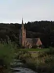
| |||
| Old Stow Kirk and Burial Ground | 55°41′29″N 2°51′42″W / 55.691461°N 2.861665°W | Category B | 17404 | 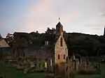
| |||
| Bowland House Including Garden Cottages, Walled Garden And Garage Block | 55°38′59″N 2°52′51″W / 55.649669°N 2.880737°W | Category B | 17407 | Upload Photo | |||
| Symington House Including Gate Lodge And Boundary Walls | 55°43′28″N 2°53′56″W / 55.724423°N 2.898866°W | Category C(S) | 51300 | Upload Photo | |||
| Torquhan House Including Gate Lodge And Gatepiers, Walled Garden And Stable Block | 55°43′12″N 2°52′54″W / 55.71991°N 2.88176°W | Category B | 17402 | Upload Photo | |||
| Luggate Water Bridge | 55°40′48″N 2°52′34″W / 55.679992°N 2.876107°W | Category B | 17399 | 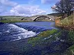
| |||
| Burn House | 55°43′59″N 2°53′46″W / 55.732951°N 2.896211°W | Category B | 17400 | Upload Photo | |||
| Plenploth Farmhouse With Boundary Walls | 55°43′39″N 2°53′44″W / 55.727466°N 2.895528°W | Category C(S) | 13900 | Upload Photo |
Key
The scheme for classifying buildings in Scotland is:
- Category A: "buildings of national or international importance, either architectural or historic; or fine, little-altered examples of some particular period, style or building type."[1]
- Category B: "buildings of regional or more than local importance; or major examples of some particular period, style or building type, which may have been altered."[1]
- Category C: "buildings of local importance; lesser examples of any period, style, or building type, as originally constructed or moderately altered; and simple traditional buildings which group well with other listed buildings."[1]
In March 2016 there were 47,288 listed buildings in Scotland. Of these, 8% were Category A, and 50% were Category B, with the remaining 42% being Category C.[2]
Notes
- ↑ Sometimes known as OSGB36, the grid reference (where provided) is based on the British national grid reference system used by the Ordnance Survey.
• "Guide to National Grid". Ordnance Survey. Retrieved 12 December 2007.
• "Get-a-map". Ordnance Survey. Retrieved 17 December 2007. - ↑ Historic Environment Scotland assign a unique alphanumeric identifier to each designated site in Scotland, for listed buildings this always begins with "LB", for example "LB12345".
References
- All entries, addresses and coordinates are based on data from Historic Scotland. This data falls under the Open Government Licence
- 1 2 3 "What is Listing?". Historic Environment Scotland. Retrieved 29 May 2018.
- ↑ Scotland's Historic Environment Audit 2016 (PDF). Historic Environment Scotland and the Built Environment Forum Scotland. pp. 15–16. Retrieved 29 May 2018.
This article is issued from Wikipedia. The text is licensed under Creative Commons - Attribution - Sharealike. Additional terms may apply for the media files.