This is a list of listed buildings in the parish of Fogo in the Scottish Borders, Scotland.
List
| Name | Location | Date Listed | Grid Ref. [note 1] | Geo-coordinates | Notes | LB Number [note 2] | Image |
|---|---|---|---|---|---|---|---|
| Caldra Farm Including Farmhouse, Cottages And Gatepiers | 55°44′24″N 2°21′51″W / 55.739868°N 2.364185°W | Category B | 10514 |  Upload Photo | |||
| 1 - 10 (Inclusive Numbers) Bogend Farm Cottages Including Ancillary Structure And Railings | 55°44′13″N 2°19′44″W / 55.737056°N 2.329027°W | Category C(S) | 45763 | Upload Photo | |||
| Fogomuir Cottages Including Garden Wall | 55°43′24″N 2°22′41″W / 55.723258°N 2.378072°W | Category C(S) | 45773 | Upload Photo | |||
| Caldra House, Walled Garden Including Bothy | 55°44′12″N 2°21′54″W / 55.736613°N 2.365126°W | Category C(S) | 45766 | Upload Photo | |||
| Charterhall House Including Office Range, Courtyard Cottage And Sundial | 55°43′07″N 2°22′42″W / 55.718639°N 2.37825°W | Category B | 45767 | Upload Photo | |||
| Charterhall, Lodge Including Quadrant Walls, Gatepiers And Gates | 55°43′06″N 2°22′56″W / 55.71833°N 2.38229°W | Category C(S) | 45768 | Upload Photo | |||
| Charterhall, Stable Courtyard Including Cobbled Drive And Courtyard, Gatepiers, Groom's Cottage And Stable Cottages | 55°43′10″N 2°22′47″W / 55.719407°N 2.379754°W | Category B | 45770 | Upload Photo | |||
| Fogo House (Former Manse) Including Stable Block, Garden Walls, Boundary Walls And Gatepiers | 55°44′05″N 2°21′49″W / 55.734838°N 2.363581°W | Category C(S) | 45771 | Upload Photo | |||
| Cairn's Mill Cottage Including Mill Steading And Cairn's Mill | 55°44′19″N 2°20′22″W / 55.738529°N 2.339391°W | Category C(S) | 45764 | Upload Photo | |||
| Harcarse Farmhouse Including Railings, Gatepiers And Gate | 55°43′54″N 2°18′03″W / 55.731774°N 2.300814°W | Category C(S) | 45775 | Upload Photo | |||
| Fogo Kirk, Church Of Scotland, Including Inner And Outer Graveyards, Boundary Walls And Lych Gate | 55°44′08″N 2°21′49″W / 55.73562°N 2.363747°W | Category A | 10512 | 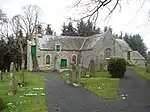
| |||
| Fogo Former School Including Railings | 55°44′04″N 2°21′54″W / 55.734394°N 2.365089°W | Category C(S) | 45772 | Upload Photo | |||
| Fogorig Farmhouse Including Ancillary Structures, Garden Walls And Boundary Walls | 55°43′35″N 2°21′32″W / 55.726308°N 2.358773°W | Category C(S) | 45774 | Upload Photo | |||
| Studio Cottage Including Cobbled Forecourt | 55°44′04″N 2°21′53″W / 55.734457°N 2.364803°W | Category C(S) | 45776 | Upload Photo | |||
| Whinkerstones Farm Cottage | 55°43′01″N 2°22′01″W / 55.716903°N 2.367027°W | Category C(S) | 45777 | Upload Photo | |||
| Fogo Bridge | 55°44′08″N 2°22′05″W / 55.735669°N 2.368143°W | Category A | 10513 | 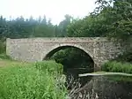
| |||
| Caldra House, Quadrant Walls, Railings, Piers, Gatepiers And Gates | 55°44′23″N 2°21′50″W / 55.739663°N 2.363896°W | Category C(S) | 45765 | Upload Photo | |||
| Charterhall, South Lodge Including Quadrant Walls, Piers, Gatepiers And Gates | 55°42′43″N 2°22′00″W / 55.711827°N 2.366773°W | Category B | 45769 | Upload Photo |
Key
The scheme for classifying buildings in Scotland is:
- Category A: "buildings of national or international importance, either architectural or historic; or fine, little-altered examples of some particular period, style or building type."[1]
- Category B: "buildings of regional or more than local importance; or major examples of some particular period, style or building type, which may have been altered."[1]
- Category C: "buildings of local importance; lesser examples of any period, style, or building type, as originally constructed or moderately altered; and simple traditional buildings which group well with other listed buildings."[1]
In March 2016 there were 47,288 listed buildings in Scotland. Of these, 8% were Category A, and 50% were Category B, with the remaining 42% being Category C.[2]
Notes
- ↑ Sometimes known as OSGB36, the grid reference (where provided) is based on the British national grid reference system used by the Ordnance Survey.
• "Guide to National Grid". Ordnance Survey. Retrieved 12 December 2007.
• "Get-a-map". Ordnance Survey. Retrieved 17 December 2007. - ↑ Historic Environment Scotland assign a unique alphanumeric identifier to each designated site in Scotland, for listed buildings this always begins with "LB", for example "LB12345".
References
- All entries, addresses and coordinates are based on data from Historic Scotland. This data falls under the Open Government Licence
- 1 2 3 "What is Listing?". Historic Environment Scotland. Retrieved 29 May 2018.
- ↑ Scotland's Historic Environment Audit 2016 (PDF). Historic Environment Scotland and the Built Environment Forum Scotland. pp. 15–16. Retrieved 29 May 2018.
This article is issued from Wikipedia. The text is licensed under Creative Commons - Attribution - Sharealike. Additional terms may apply for the media files.