This list is of the Places of Scenic Beauty of Japan located within the Prefecture of Kumamoto.[1]
National Places of Scenic Beauty
As of 1 November 2021, ten Places have been designated at a national level.[2][3][4]


Prefectural Places of Scenic Beauty
As of 1 May 2021, three Places have been designated at a prefectural level.[4][5]
| Site | Municipality | Comments | Image | Coordinates | Type | Ref. |
|---|---|---|---|---|---|---|
| Unganzen-ji Precinct 雲巌禅寺境内 Unganzenji keidai | Kumamoto | also a Prefectural Historic Site |  | 32°49′10″N 130°37′22″E / 32.819583°N 130.622833°E | for all refs see | |
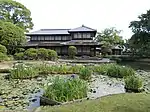
| Mangan-ji Gardens 満願寺庭園 Manganji teien | Minamioguni | also a Prefectural Historic Site |  | 33°04′34″N 131°05′45″E / 33.076125°N 131.095927°E | ||
| Uto Peninsula Okoshiki Coast and Surrounding Sands 宇土半島の御輿来海岸及びその周辺の砂 Uto-hantō no Okoshiki-kaigan oyobi sono shūhen no sa | Uto | |||||
Municipal Places of Scenic Beauty
As of 1 May 2021, thirty Places have been designated at a municipal level, including:[4][6]
| Site | Municipality | Comments | Image | Coordinates | Type | Ref. |
|---|---|---|---|---|---|---|
| Zuigan-ji Site 瑞巌寺跡 Zuiganji ato | Kumamoto | also a Municipal Historic Site | 32°50′52″N 130°41′17″E / 32.847735°N 130.688069°E | |||
| Sairyū-en 栽柳園 Sairyū-en | Yatsushiro | 32°29′34″N 130°36′11″E / 32.492654°N 130.603071°E | ||||
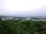
| Kogase 小ヶ瀬 Kogase | Amakusa | 32°19′17″N 129°57′39″E / 32.321423°N 129.960849°E | ||||
Registered Places of Scenic Beauty
As of 1 November 2021, one Monument has been registered (as opposed to designated) as a Place of Scenic Beauty at a national level.[3][7]
| Place | Municipality | Comments | Image | Coordinates | Type | Ref. |
|---|---|---|---|---|---|---|
| Shiramizu Falls 白水の滝 Shiramizu no taki | Takamori | designation spans the borders with Taketa, Ōita | 32°52′57″N 131°16′40″E / 32.882518°N 131.277896°E | |||


See also
- Cultural Properties of Japan
- List of parks and gardens of Kumamoto Prefecture
- List of Historic Sites of Japan (Kumamoto)
- List of Cultural Properties of Japan - paintings (Kumamoto)
External links
- (in Japanese) Cultural Properties in Kumamoto Prefecture
References
- ↑ "Cultural Properties for Future Generations". Agency for Cultural Affairs. Retrieved 24 November 2021.
- ↑ 史跡名勝天然記念物 [Number of Monuments of Japan by Prefecture] (in Japanese). Agency for Cultural Affairs. 1 November 2021. Retrieved 24 November 2021.
- 1 2 "Database of National Cultural Properties: 史跡名勝天然記念物 (名勝, 特別名勝 熊本県)" (in Japanese). Agency for Cultural Affairs. Retrieved 24 November 2021.
- 1 2 3 指定文化財数 [Number of Cultural Properties] (in Japanese). Kumamoto Prefecture. 1 August 2021. Retrieved 24 November 2021.
- ↑ 都道府県別指定等文化財件数(都道府県分) [Number of Prefectural Cultural Properties by Prefecture] (in Japanese). Agency for Cultural Affairs. 1 May 2021. Retrieved 24 November 2021.
- ↑ 都道府県別指定等文化財件数(市町村分) [Number of Municipal Cultural Properties by Prefecture] (in Japanese). Agency for Cultural Affairs. 1 May 2021. Retrieved 24 November 2021.
- ↑ 登録文化財 [Number of Registered Cultural Properties by Prefecture] (in Japanese). Agency for Cultural Affairs. 1 November 2021. Retrieved 24 November 2021.
This article is issued from Wikipedia. The text is licensed under Creative Commons - Attribution - Sharealike. Additional terms may apply for the media files.