This list is of the Places of Scenic Beauty of Japan located within the Prefecture of Gunma.[1]
National Places of Scenic Beauty
As of 1 August 2020, eight Places have been designated at a national level; Sanbaseki Gorge spans the prefectural borders with Saitama.[2][3][4]


Prefectural Places of Scenic Beauty
As of 1 May 2019, five Places have been designated at a prefectural level.[4][5]
| Site | Municipality | Comments | Image | Coordinates | Type | Ref. |
|---|---|---|---|---|---|---|
| Takizawa Fudō Falls 滝沢の不動滝 Takizawa-no-Fudō-no-taki | Maebashi | 36°30′32″N 139°11′17″E / 36.508929°N 139.187990°E | for all refs see | |||
| Mount Kawate Caves and Zunyite 川手山洞窟群及びズニ石 Kawate-yama dōkutsu-gun oyobi zuni-ishi | Minakami | also a Prefectural Natural Monument | 36°40′36″N 138°50′38″E / 36.676783°N 138.843927°E | |||
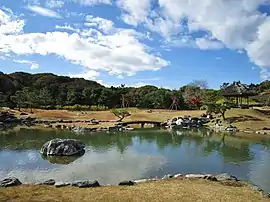
| Mount Ōmine floating islands and marshland plants 大峰山浮島及び湿原植物 Ōmine-yama ukishima oyobi shitsugen shokubutsu | Minakami | also a Prefectural Natural Monument | 36°44′03″N 138°56′01″E / 36.734276°N 138.933706°E | |||
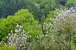
| Semi Valley 蝉の渓谷 Semi-no-keikoku | Nanmoku | also a Prefectural Natural Monument | _1.jpg.webp) | 36°09′24″N 138°40′52″E / 36.156588°N 138.681192°E | ||
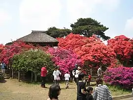
| Sengataki Falls 線ヶ滝 Sengataki | Nanmoku | also a Prefectural Natural Monument |  | 36°10′44″N 138°38′15″E / 36.178969°N 138.637419°E | ||
Municipal Places of Scenic Beauty
As of 1 May 2019, twenty-seven Places have been designated at a municipal level.[6]


See also
- Cultural Properties of Japan
- List of parks and gardens of Gunma Prefecture
- List of Historic Sites of Japan (Gunma)
References
- ↑ "Cultural Properties for Future Generations". Agency for Cultural Affairs. Retrieved 2 August 2020.
- ↑ 史跡名勝天然記念物 [Number of Monuments of Japan by Prefecture] (in Japanese). Agency for Cultural Affairs. 1 August 2020. Retrieved 2 August 2020.
- ↑ "Database of National Cultural Properties: 史跡名勝天然記念物 (名勝, 特別名勝 群馬県 2県以上)" (in Japanese). Agency for Cultural Affairs. Retrieved 2 August 2020.
- 1 2 群馬の文化財 [Cultural Properties of Gunma Prefecture] (in Japanese). Gunma Prefecture. 12 June 2020. Retrieved 2 August 2020.
- ↑ 都道府県別指定等文化財件数(都道府県分) [Number of Prefectural Cultural Properties by Prefecture] (in Japanese). Agency for Cultural Affairs. 1 May 2019. Retrieved 2 August 2020.
- ↑ 都道府県別指定等文化財件数(市町村分) [Number of Municipal Cultural Properties by Prefecture] (in Japanese). Agency for Cultural Affairs. 1 May 2019. Retrieved 2 August 2020.
External links
- (in Japanese) Cultural Properties in Gunma Prefecture
This article is issued from Wikipedia. The text is licensed under Creative Commons - Attribution - Sharealike. Additional terms may apply for the media files.