La Ferté-Saint-Samson | |
|---|---|
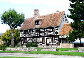 The house of Henry IV in La Ferté-Saint-Samson | |
.svg.png.webp) Coat of arms | |
Location of La Ferté-Saint-Samson | |
 La Ferté-Saint-Samson  La Ferté-Saint-Samson | |
| Coordinates: 49°34′44″N 1°31′32″E / 49.5789°N 1.5256°E | |
| Country | France |
| Region | Normandy |
| Department | Seine-Maritime |
| Arrondissement | Dieppe |
| Canton | Gournay-en-Bray |
| Intercommunality | CC 4 rivières |
| Government | |
| • Mayor (2020–2026) | Maurice Defromerie[1] |
| Area 1 | 19.05 km2 (7.36 sq mi) |
| Population | 444 |
| • Density | 23/km2 (60/sq mi) |
| Time zone | UTC+01:00 (CET) |
| • Summer (DST) | UTC+02:00 (CEST) |
| INSEE/Postal code | 76261 /76440 |
| Elevation | 119–196 m (390–643 ft) (avg. 190 m or 620 ft) |
| 1 French Land Register data, which excludes lakes, ponds, glaciers > 1 km2 (0.386 sq mi or 247 acres) and river estuaries. | |
La Ferté-Saint-Samson is a commune in the Seine-Maritime department in the Normandy region in northern France.
Geography
A forestry and farming village situated in the Pays de Bray, some 39 miles (63 km) southeast of Dieppe at the junction of the D61, the D21 and the D921 roads.
Population
| Year | Pop. | ±% p.a. |
|---|---|---|
| 1968 | 447 | — |
| 1975 | 372 | −2.59% |
| 1982 | 319 | −2.17% |
| 1990 | 333 | +0.54% |
| 1999 | 341 | +0.26% |
| 2007 | 425 | +2.79% |
| 2012 | 460 | +1.60% |
| 2017 | 466 | +0.26% |
| Source: INSEE[3] | ||
Places of interest
See also
References
- ↑ "Répertoire national des élus: les maires" (in French). data.gouv.fr, Plateforme ouverte des données publiques françaises. 13 September 2022.
- ↑ "Populations légales 2021". The National Institute of Statistics and Economic Studies. 28 December 2023.
- ↑ Population en historique depuis 1968, INSEE
Wikimedia Commons has media related to La Ferté-Saint-Samson.
This article is issued from Wikipedia. The text is licensed under Creative Commons - Attribution - Sharealike. Additional terms may apply for the media files.