Hůry | |
|---|---|
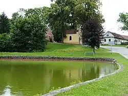 Chapel of Saint Florian in the centre of Hůry | |
 Flag  Coat of arms | |
 Hůry Location in the Czech Republic | |
| Coordinates: 49°0′24″N 14°32′28″E / 49.00667°N 14.54111°E | |
| Country | |
| Region | South Bohemian |
| District | České Budějovice |
| First mentioned | 1378 |
| Area | |
| • Total | 5.34 km2 (2.06 sq mi) |
| Elevation | 467 m (1,532 ft) |
| Population (2023-01-01)[1] | |
| • Total | 615 |
| • Density | 120/km2 (300/sq mi) |
| Time zone | UTC+1 (CET) |
| • Summer (DST) | UTC+2 (CEST) |
| Postal code | 373 71 |
| Website | www |
Hůry is a municipality and village in České Budějovice District in the South Bohemian Region of the Czech Republic. It has about 600 inhabitants.
Hůry lies approximately 6 kilometres (4 mi) north-east of České Budějovice and 121 km (75 mi) south of Prague.
References
Wikimedia Commons has media related to Hůry.
This article is issued from Wikipedia. The text is licensed under Creative Commons - Attribution - Sharealike. Additional terms may apply for the media files.