Chazay-d'Azergues | |
|---|---|
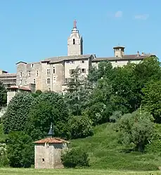 A view of the citadel of Chazay-d'Azergues | |
.svg.png.webp) Coat of arms | |
Location of Chazay-d'Azergues | |
 Chazay-d'Azergues 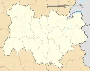 Chazay-d'Azergues | |
| Coordinates: 45°52′01″N 4°43′01″E / 45.867°N 4.717°E | |
| Country | France |
| Region | Auvergne-Rhône-Alpes |
| Department | Rhône |
| Arrondissement | Villefranche-sur-Saône |
| Canton | Anse |
| Intercommunality | CC Beaujolais Pierres Dorées |
| Government | |
| • Mayor (2020–2026) | Pascale Bay[1] |
| Area 1 | 5.94 km2 (2.29 sq mi) |
| Population | 4,164 |
| • Density | 700/km2 (1,800/sq mi) |
| Time zone | UTC+01:00 (CET) |
| • Summer (DST) | UTC+02:00 (CEST) |
| INSEE/Postal code | 69052 /69380 |
| Elevation | 179–311 m (587–1,020 ft) (avg. 210 m or 690 ft) |
| Website | www |
| 1 French Land Register data, which excludes lakes, ponds, glaciers > 1 km2 (0.386 sq mi or 247 acres) and river estuaries. | |
Chazay-d'Azergues (French pronunciation: [ʃazɛ dazɛʁɡ], literally Chazay of Azergues) is a commune in the Rhône department in eastern France.
Population
| Year | Pop. | ±% p.a. |
|---|---|---|
| 1968 | 1,479 | — |
| 1975 | 2,054 | +4.80% |
| 1982 | 2,712 | +4.05% |
| 1990 | 3,314 | +2.54% |
| 1999 | 3,903 | +1.83% |
| 2007 | 3,906 | +0.01% |
| 2012 | 3,943 | +0.19% |
| 2017 | 4,130 | +0.93% |
| Source: INSEE[3] | ||
See also
References
- ↑ "Répertoire national des élus: les maires" (in French). data.gouv.fr, Plateforme ouverte des données publiques françaises. 13 September 2022.
- ↑ "Populations légales 2021". The National Institute of Statistics and Economic Studies. 28 December 2023.
- ↑ Population en historique depuis 1968, INSEE
Wikimedia Commons has media related to Chazay-d'Azergues.
This article is issued from Wikipedia. The text is licensed under Creative Commons - Attribution - Sharealike. Additional terms may apply for the media files.