Élise-Daucourt | |
|---|---|
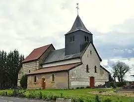 St. Nicholas' Church in Daucourt | |
Location of Élise-Daucourt | |
 Élise-Daucourt  Élise-Daucourt | |
| Coordinates: 49°02′48″N 4°52′04″E / 49.0467°N 4.8678°E | |
| Country | France |
| Region | Grand Est |
| Department | Marne |
| Arrondissement | Châlons-en-Champagne |
| Canton | Argonne Suippe et Vesle |
| Intercommunality | Argonne Champenoise |
| Government | |
| • Mayor (2020–2026) | Guillaume Achard-Corompt[1] |
| Area 1 | 15.32 km2 (5.92 sq mi) |
| Population | 82 |
| • Density | 5.4/km2 (14/sq mi) |
| Time zone | UTC+01:00 (CET) |
| • Summer (DST) | UTC+02:00 (CEST) |
| INSEE/Postal code | 51228 /51800 |
| 1 French Land Register data, which excludes lakes, ponds, glaciers > 1 km2 (0.386 sq mi or 247 acres) and river estuaries. | |
Élise-Daucourt (French pronunciation: [eliz dokuʁ]) is a commune in the Marne department in north-eastern France. The commune consists of 2 villages, Élise and Daucourt, which are 1 mile apart. Both villages were separate communes until 1965, when they merged. Since the merger Élise is often called Élise-Daucourt. Both villages lie about 6 km south of Sainte-Menehould, the nearest regional town.
See also
.JPG.webp) Church of St. Julian in Élise
Church of St. Julian in Élise.JPG.webp) Former town hall of Élise
Former town hall of Élise.JPG.webp) Rural corner in Élise
Rural corner in Élise
References
- ↑ "Répertoire national des élus: les maires" (in French). data.gouv.fr, Plateforme ouverte des données publiques françaises. 13 September 2022.
- ↑ "Populations légales 2021". The National Institute of Statistics and Economic Studies. 28 December 2023.
External links
Wikimedia Commons has media related to Élise-Daucourt.
This article is issued from Wikipedia. The text is licensed under Creative Commons - Attribution - Sharealike. Additional terms may apply for the media files.