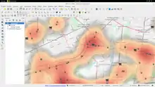

Quantum GIS (GQIS) Heatmap
Early Warning and Automated Response System
Early Warning and Automated Response System (EWARS) is a system to support spatial decision support. Spatial pattern of risk and spatial allocation of resources according to risk is a primary objective
Mathematical Analysis and Processing of spatial Pattern and Processes
For spatial decision support the following basics are recommended for your learning steps:
- Moving Average is used to smooth spatial data. For this learning objective it is necessary to examine the the moving average in discrete and continuous setting and on image processing as a first step.
- (Health Maps and Animation) Analyse how to create a webbased heatmap with Leaflet[2] of OpenLayers for visualize spatial pattern of high risk areas for communicable diseases.
Learning Task
- (Capacity Building) Learn about international approaches to combine Capacity Building and Open Educational Resource for Global Health. Apply the ideas to Spatial Epidemiology and learning resource in sense of Think globally - act locally[3]!
- (Spatial Risk Map) Analyse the COVID-19 outbreak 2019/20 and check how a spatial risk map can be created by using webbased technology (see COVID-19/Time Series and COVID-19 Data).
See also
References
- ↑ UN-Guidelines for Use of SDG logo and the 17 SDG icons (2016/10) - http://www.un.org/sustainabledevelopment/wp-content/uploads/2016/10/UN-Guidelines-for-Use-of-SDG-logo-and-17-icons.October-2016.pdf
- ↑ Guthub Repository Heatmap Plugin for Leaflet (2016) GitHub Leaflet/Leaflet.heat - URL: https://github.com/Leaflet/Leaflet.heat (accessed 2020/03/20)
- ↑ Kefalas, A. G. (1998). Think globally, act locally. Thunderbird International Business Review, 40(6), 547-562.
This article is issued from Wikiversity. The text is licensed under Creative Commons - Attribution - Sharealike. Additional terms may apply for the media files.