150
THE GENERAL'S HUT.
in many place's hang declining over passengers and higher than houses, so that 'tis frightful to pass by them."[1] A Volunteer describes the mountains "as high and frightful as the Alps in Spain; so we had nothing pleasant to behold but the sky."[2]
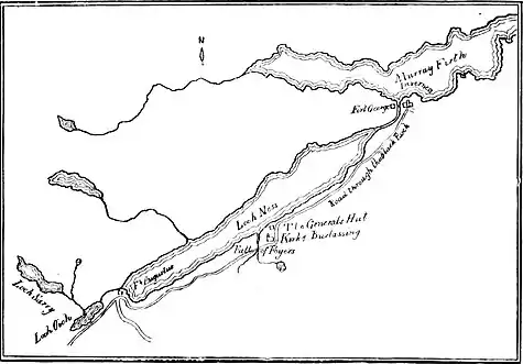
Our travellers halted for dinner at the General's Hut, a small public-house nearly eighteen miles from Inverness.[3] Here, says Johnson, Wade had lodged "while he superintended the works upon the road." I have seen it stated in a guide-book that on its site is built the Foyer's Hotel, but this is a mistake. In the Map of the Kings Roads made by General Wade, dated 1746, "the General Hutt" (sic) is marked just where the road takes a sudden

MAP OF FOYERS.
bend to the south, a short distance after which it passes the church of Burlassig. Dr. Garnett, who travelled through the Highlands at the end of the century, says that "the present public-house, which is still called the General's Hut, is very near the place where Wade had a small house, which was afterwards used as an inn. It commands a delightful view up the lake." The change of site must have been made, it would seem, between his visit and Johnson's.
- ↑ Ray's History of the Rebellion, p. 362.
- ↑ M. Hughes's Plain Narrative, p. 53. Alps, I suppose, he uses as Milton does for lofty mountains in general.
- ↑ In a Survey of the Province of Moray, published at Aberdeen in 1798, on pp. 333-34, the following table is given of the distances along the road which Johnson was following:—"From Inverness to the General's Hut, 17 miles 6 furlongs. From General's Hut to Fort Augustus, 14 miles 2 furlongs. From Fort Augustus to Unach [? Anoch], 9 miles. From Unach to Rattachan, 25 miles 5 furlongs. From Rattachan to Bernera, 9 miles.