Wunsiedel
Wunsiedel (German pronunciation: [ˈvʊnˌziːdl̩] (![]() listen)) is the seat of the Upper Franconian district of Wunsiedel in northeast Bavaria, Germany.
listen)) is the seat of the Upper Franconian district of Wunsiedel in northeast Bavaria, Germany.
Wunsiedel | |
|---|---|
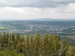 View on the town | |
 Coat of arms | |
Location of Wunsiedel within Wunsiedel im Fichtelgebirge district 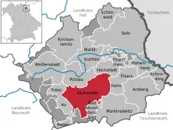 | |
 Wunsiedel  Wunsiedel | |
| Coordinates: 50°1′N 12°1′E | |
| Country | Germany |
| State | Bavaria |
| Admin. region | Upper Franconia |
| District | Wunsiedel im Fichtelgebirge |
| Government | |
| • Mayor (2020–26) | Nicolas Lahovnik[1] (CSU) |
| Area | |
| • Total | 54.91 km2 (21.20 sq mi) |
| Elevation | 525 m (1,722 ft) |
| Population (2022-12-31)[2] | |
| • Total | 9,243 |
| • Density | 170/km2 (440/sq mi) |
| Time zone | UTC+01:00 (CET) |
| • Summer (DST) | UTC+02:00 (CEST) |
| Postal codes | 95632 |
| Dialling codes | 09232 |
| Vehicle registration | WUN |
| Website | wunsiedel |
Geography
Wunsiedel is in the Fichtelgebirge Mountains in the valley of the Röslau at the foot of the Kösseine Plateau.
Incorporated villages
The town's borough has the following villages (year of incorporation in brackets):
Bernstein (1978), Breitenbrunn, Furthammer, Göpfersgrün, Göringsreuth, Hauenreuth, Hildenbach (1978), Hildenmühle, Holenbrunn (1978), Johanneszeche, Juliushammer, Klause, Kösseinehaus, Krohenhammer, Luisenburg, Schneckenhammer, Schneckenmühle, Schönbrunn (1975), Sinatengrün, Stemmasgrün, Stollenmühle, Valetsberg, Walkmühle, Wiesenmühle, Wintersberg, Wintersreuth.
Twin towns and cities
Wunsiedel is twinned with:
 Torbalı, Turkey, since 1980
 Mende, France, since 1980
 Schwarzenberg, Germany, since 1990
 Volterra, Italy, since 2006
 Ostrov, Czech Republic, since 2009
References
- Liste der ersten Bürgermeister/Oberbürgermeister in kreisangehörigen Gemeinden, Bayerisches Landesamt für Statistik, 15 July 2021.
- Genesis Online-Datenbank des Bayerischen Landesamtes für Statistik Tabelle 12411-003r Fortschreibung des Bevölkerungsstandes: Gemeinden, Stichtag (Einwohnerzahlen auf Grundlage des Zensus 2011) .
Sources
- Die Kunstdenkmäler von Oberfranken, Bd. 1: Landkreis Wunsiedel und Stadtkreis Marktredwitz. 1954. ISBN 978-3-486-41941-2
Other websites
Wikimedia Commons has media related to Wunsiedel.
Wikisource has original writing related to this article:
- Town of Wunsiedel (in German)
- District of Wunsiedel (in German)
- Information at Bayern-Fichtelgebirge (in German)
- "Wunsiedel: History of the coat-of-arms" (in German). Haus der Bayerischen Geschichte.
This article is issued from Wikipedia. The text is licensed under Creative Commons - Attribution - Sharealike. Additional terms may apply for the media files.