Vining, Kansas
Vining is a city in Clay and Washington counties in Kansas, United States. In 2020, 43 people lived there.[3]
Vining, Kansas | |
|---|---|
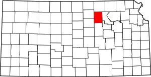
 Location within Washington County and Kansas | |
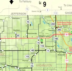 KDOT map of Washington County (legend) | |
| Coordinates: 39°34′02″N 97°17′37″W[1] | |
| Country | United States |
| State | Kansas |
| Counties | Clay, Washington |
| Platted | 1877 (West Clifton) |
| Incorporated | 1885 |
| Area | |
| • Total | 0.21 sq mi (0.55 km2) |
| • Land | 0.21 sq mi (0.55 km2) |
| • Water | 0.00 sq mi (0.00 km2) |
| Elevation | 1,273 ft (388 m) |
| Population | |
| • Total | 43 |
| • Density | 200/sq mi (78/km2) |
| Time zone | UTC-6 (CST) |
| • Summer (DST) | UTC-5 (CDT) |
| Area code | 785 |
| FIPS code | 20-73950 |
| GNIS ID | 2397147[1] |
History
Vining was first called West Clifton. It was planned out as West Clifton in 1877. It was renamed Vining in 1881, in honor of E. P. Vining, a railroad worker.[4]
Vining was once an important shipping point. This was because it was on the Republican River and at the junction of two railroads.[5]
The post office in Vining closed in 1955.[6]
Geography
Vining is at 39°34′2″N 97°17′37″W (39.567319, -97.293613). The United States Census Bureau says that the city has a total area of 0.21 square miles (0.54 km2). All of it is land.[2] The city is located next to Clifton.
People
| Historical population | |||
|---|---|---|---|
| Census | Pop. | %± | |
| 1890 | 241 | — | |
| 1900 | 245 | 1.7% | |
| 1910 | 191 | −22.0% | |
| 1920 | 183 | −4.2% | |
| 1930 | 198 | 8.2% | |
| 1940 | 188 | −5.1% | |
| 1950 | 168 | −10.6% | |
| 1960 | 128 | −23.8% | |
| 1970 | 84 | −34.4% | |
| 1980 | 85 | 1.2% | |
| 1990 | 55 | −35.3% | |
| 2000 | 58 | 5.5% | |
| 2010 | 45 | −22.4% | |
| 2020 | 43 | −4.4% | |
| U.S. Decennial Census | |||
References
- U.S. Geological Survey Geographic Names Information System: Vining, Kansas
- "2020 U.S. Gazetteer Files". United States Census Bureau. Retrieved November 20, 2023.
- "DP1: PROFILE OF GENERAL POPULATION AND HOUSING CHARACTERISTICS". United States Census Bureau. Retrieved November 20, 2023.
- "Vining". Clay County, Kansas. Archived from the original on 17 May 2014. Retrieved 15 May 2014.
- Blackmar, Frank Wilson (1912). Kansas: A Cyclopedia of State History, Volume 2. Standard Publishing Company. p. 848.
- "Kansas Post Offices, 1828-1961, page 2 (archived)". Kansas Historical Society. Archived from the original on October 9, 2013. Retrieved 7 June 2014.
- "American FactFinder". United States Census Bureau. Archived from the original on 2015-03-28. Retrieved 2012-07-06.
Other websites
- City
- Schools
- Clifton-Clyde USD 224, local school district
- Maps
- Vining City Map, KDOT
Municipalities and communities of Clay County, Kansas, United States | ||
|---|---|---|
| Cities |
|  Map of Kansas highlighting Clay County |
| Unincorporated communities |
| |
| Ghost towns |
| |
| Townships |
| |
| Footnotes | †This populated place is designated a Census-Designated Place (CDP) by the United States Census Bureau. ‡This populated place also has portions in an adjacent county or counties. | |
Municipalities and communities of Washington County, Kansas, United States | ||
|---|---|---|
| Cities |  Map of Kansas highlighting Washington County | |
| Unincorporated communities |
| |
| Footnotes | ‡This populated place also has portions in an adjacent county or counties | |
This article is issued from Wikipedia. The text is licensed under Creative Commons - Attribution - Sharealike. Additional terms may apply for the media files.