Untergriesbach
Untergriesbach (Central Bavarian: Untagriasbo) is a municipality in Passau in Bavaria in Germany.
Untergriesbach | |
|---|---|
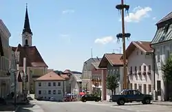 Market square | |
 Coat of arms | |
Location of Untergriesbach within Passau district  | |
 Untergriesbach  Untergriesbach | |
| Coordinates: 48°34′30″N 13°40′5″E | |
| Country | Germany |
| State | Bavaria |
| Admin. region | Niederbayern |
| District | Passau |
| Government | |
| • Mayor (2018–2024) | Hermann Duschl[1] |
| Area | |
| • Total | 73.60 km2 (28.42 sq mi) |
| Elevation | 556 m (1,824 ft) |
| Population (2022-12-31)[2] | |
| • Total | 6,071 |
| • Density | 82/km2 (210/sq mi) |
| Time zone | UTC+01:00 (CET) |
| • Summer (DST) | UTC+02:00 (CEST) |
| Postal codes | 94107 |
| Dialling codes | 08593 |
| Vehicle registration | PA |
| Website | www |
Geography
Untergriesbach is in the southern Bavarian Forest and extends high above the deep valley of the Danube. The height of the market town is 565 meters above sea level. Via the Bundesstraße 388 it is connected to Passau (22 km) and in the opposite direction to the Upper Austrian Haslach (32 km).
Untergriesbach in Passau district
Municipality arrangement
Untergriesbach has 106 districts:[3]
- Bachhäusl
- Berghof
- Brunnreut
- Dienberg
- Diendorf
- Dürrmühle
- Eck
- Eckersäg
- Eckerstampf
- Eckmühle
- Endsfelden
- Feldhäuslhäusl
- Ficht
- Fichtwiesen
- Friedlgrub
- Gammertshof
- Gebrechtshof
- Gebrechtsmühle
- Glotzing
- Gotting
- Gottsdorf
- Grögöd
- Grub
- Grunau
- Habersdorf
- Hamet
- Hanzing
- Hastorf
- Haunersdorf
- Herrenwies
- Hinterkühberg
- Hintersäg
- Hitzing
- Hochreut
- Hochwiesl
- Höhenberg
- Holzhäusl
- Hubing
- Hundsruck
- Jochenstein
- Kagerreut
- Kappelgarten
- Kinzesberg
- Knapphäusl
- Knittlmühle
- Kohlbachmühle
- Kroding
- Kronawitten
- Kronawitthof
- Krottenthal
- Kühberg
- Lämersdorf
- Leizesberg
- Linden
- Lindlmühle
- Mairau
- Mittereck
- Mitterreut
- Nebling
- Neureuth
- Niederdorf
- Oberöd
- Oberötzdorf
- Oberreut
- Ochsenreut
- Ornatsöd
- Paulusberg
- Pfaffenreut
- Priel
- Ramesberg
- Rampersdorf
- Ratzing
- Rechab
- Reut
- Richtermühle
- Riedl
- Riedlerhof
- Roll
- Rothkreuz
- Saxing
- Schaibing
- Schergendorf
- Scherleinsöd
- Schreinerhäusl
- Spechting
- Sperrhäusl
- Steinbruck
- Steinbüchl
- Stollberg
- Stollbergmühle
- Tabakstampf
- Taubing
- Untergriesbach
- Unteröd
- Unterötzdorf
- Unterreut
- Vorholz
- Waldfriede
- Weidwies
- Wesseslinden
- Willersdorf
- Würm
- Würmmühle
- Zaunbrechl
- Ziering
- Zipf
Incorporations
On 1 October 1971, the previously independent municipality Lambsdorf was incorporated. On 1 January 1972 Gottsdorf and Schaibing were added. Oberötzdorf followed on 1 March 1972.
References
![]() Media related to Untergriesbach at Wikimedia Commons
Media related to Untergriesbach at Wikimedia Commons
- Liste der ersten Bürgermeister/Oberbürgermeister in kreisangehörigen Gemeinden, Bayerisches Landesamt für Statistik, accessed 19 July 2021.
- Genesis Online-Datenbank des Bayerischen Landesamtes für Statistik Tabelle 12411-003r Fortschreibung des Bevölkerungsstandes: Gemeinden, Stichtag (Einwohnerzahlen auf Grundlage des Zensus 2011) .
- Untergriesbach in Bayerische Landesbibliothek Online
This article is issued from Wikipedia. The text is licensed under Creative Commons - Attribution - Sharealike. Additional terms may apply for the media files.