Umatilla County, Oregon
Umatilla County (/ˌjuːməˈtɪlə/) is a county in the U.S. state of Oregon. The county seat is Umatilla. In 2020, 80,075 people lived there.[1] The county includes 3,231 square miles (8,369 km2) of which 3,215 is land and the rest is water.
Umatilla County | |
|---|---|
 Stafford Hansell Government Center in Hermiston | |
 Location within the U.S. state of Oregon | |
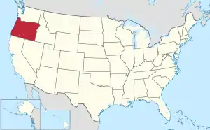 Oregon's location within the U.S. | |
| Coordinates: 45°22′30″N 118°45′05″W | |
| Country | |
| State | |
| Founded | September 27, 1862 |
| Named for | Umatilla River |
| Seat | Pendleton |
| Largest city | Hermiston |
| Area | |
| • Total | 3,231 sq mi (8,370 km2) |
| • Land | 3,216 sq mi (8,330 km2) |
| • Water | 16 sq mi (40 km2) 0.5% |
| Population (2020) | |
| • Total | 80,075 |
| • Density | 20/sq mi (9/km2) |
| Time zone | UTC−8 (Pacific) |
| • Summer (DST) | UTC−7 (PDT) |
| Congressional district | 2nd |
| Website | www |
References
- "QuickFacts: Umatilla County, Oregon". United States Census Bureau. Retrieved January 20, 2024.
Salem (capital) | |||||||
| Topics |
|  | |||||
| Society | |||||||
| Regions |
| ||||||
| Metro areas |
| ||||||
| Largest cities |
| ||||||
| Counties | |||||||
This article is issued from Wikipedia. The text is licensed under Creative Commons - Attribution - Sharealike. Additional terms may apply for the media files.