Towanda, Kansas
Towanda is a city in Butler County, Kansas, United States. In 2020, 1,447 people lived there.[3]
Towanda, Kansas | |
|---|---|
 Location within Butler County and Kansas | |
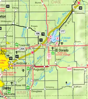 KDOT map of Butler County (legend) | |
| Coordinates: 37°47′43″N 96°59′47″W[1] | |
| Country | United States |
| State | Kansas |
| County | Butler |
| Founded | 1870 |
| Incorporated | 1905 |
| Government | |
| • Type | Council-Mayor |
| Area | |
| • Total | 0.92 sq mi (2.38 km2) |
| • Land | 0.91 sq mi (2.37 km2) |
| • Water | 0.01 sq mi (0.01 km2) |
| Elevation | 1,293 ft (394 m) |
| Population | |
| • Total | 1,447 |
| • Density | 1,600/sq mi (610/km2) |
| Time zone | UTC-6 (CST) |
| • Summer (DST) | UTC-5 (CDT) |
| ZIP code | 67144 |
| Area code | 316 |
| FIPS code | 20-71125 |
| GNIS ID | 2397041[1] |
| Website | cityoftowanda.com |
History
Towanda was created in 1870.[4][5] It was incorporated in 1905.[6] Towanda is an Osage-language name meaning "many waters".[7]
The town was damaged badly by a cyclone in 1892.[8]
21st century
In 2010, the Keystone-Cushing Pipeline (Phase II) was built a few blocks west of Towanda.[9][10] There was a lot of controversy about tax exemption and environmental concerns (if a leak ever happens).
Geography
Towanda is at 37°47′45″N 96°59′58″W (37.795921, -96.999380).[11] It is along the Whitewater River. The United States Census Bureau says that the city has a total area of 0.92 square miles (2.38 km2). Of that, 0.91 square miles (2.36 km2) is land and 0.01 square miles (0.03 km2) is water.[2]
People
| Historical population | |||
|---|---|---|---|
| Census | Pop. | %± | |
| 1880 | 53 | — | |
| 1890 | 156 | 194.3% | |
| 1910 | 275 | — | |
| 1920 | 718 | 161.1% | |
| 1930 | 424 | −40.9% | |
| 1940 | 374 | −11.8% | |
| 1950 | 417 | 11.5% | |
| 1960 | 1,031 | 147.2% | |
| 1970 | 1,190 | 15.4% | |
| 1980 | 1,332 | 11.9% | |
| 1990 | 1,289 | −3.2% | |
| 2000 | 1,338 | 3.8% | |
| 2010 | 1,450 | 8.4% | |
| 2020 | 1,447 | −0.2% | |
| U.S. Decennial Census | |||
2020 census
The 2020 census says that there were 1,447 people, 528 households, and 382 families living in Towanda. Of the households, 76.3% owned their home and 23.7% rented their home.
The median age was 35.2 years. Of the people, 89.7% were White, 1.4% were Native American, 1.3% were Black, 0.3% were from some other race, and 7.3% were two or more races. Hispanic or Latino of any race were 3.7% of the people.[3][12]
Education
Towanda is home to the district office of Circle USD 375. Circle USD 375 covers about 175 square miles.[14]
Famous people
- Frank H. Maynard, this old-time cowboy author lived in Towanda for a time in the 1870s.[15]
- Garner E. Shriver, U.S. Representative from Kansas
- Jordan Phillips, former five star recruit and defensive tackle for the University of Oklahoma and current Buffalo Bills
References
- U.S. Geological Survey Geographic Names Information System: Towanda, Kansas
- "2020 U.S. Gazetteer Files". United States Census Bureau. Retrieved November 20, 2023.
- "DP1: PROFILE OF GENERAL POPULATION AND HOUSING CHARACTERISTICS". United States Census Bureau. Retrieved November 20, 2023.
- Kansas State Historical Society (1916). Biennial Report of the Board of Directors of the Kansas State Historical Society. Kansas State Printing Plant. p. 152.
- "History of Towanda Township". Towanda Area Historical Museum. Retrieved 7 Nov 2019.
- "City of Towanda, Kansas". City of Towanda Official Website. Retrieved 7 Nov 2019.
- "Profile for Towanda, Kansas". ePodunk. Archived from the original on 4 March 2016. Retrieved 5 June 2014.
- Mooney, Vol. P. (1916). History of Butler County Kansas. Standard Publishing Company. p. 224.
- Keystone Pipeline - Marion County Commission calls out Legislative Leadership on Pipeline Deal; April 18, 2010. Archived October 22, 2011, at the Wayback Machine
- Keystone Pipeline - TransCanada inspecting pipeline; December 10, 2010.
- "US Gazetteer files: 2010, 2000, and 1990". United States Census Bureau. 2011-02-12. Retrieved 2011-04-23.
- "P16: HOUSEHOLD TYPE". United States Census Bureau. Retrieved January 2, 2024.
- "American FactFinder". United States Census Bureau. Retrieved 2012-07-06.
- "District Profile". Circle Public Schools. Archived from the original on 27 May 2015. Retrieved 27 May 2015.
- Frank H. Maynard, Cowboy's Lament: A Life on the Open Range (Lubbock, Texas: Texas Tech University Press, 2010), p. 3, ISBN 978-0-89672-705-2
Other websites
- City
- Schools
- USD 375, local school district
- USD 375 School District Boundary Map, KDOT
- Maps
- Towanda City Map, KDOT
Municipalities and communities of Butler County, Kansas, United States | ||
|---|---|---|
| Cities | 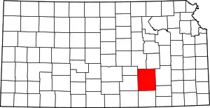 Map of Kansas highlighting Butler County | |
| Unincorporated communities |
| |
| Ghost towns |
| |
| Townships |
| |
| Footnotes | †This populated place is designated a Census-Designated Place (CDP) by the United States Census Bureau, ‡This populated place also has portions in an adjacent county or counties. | |