Tisza
The Tisza is one of the major rivers of Central Europe. It starts in Ukraine, with the White Tisza in the Chornohora and Black Tisza in the Gorgany range, and flows partially along the Romanian border. It then enters Hungary at Tiszabecs and passes through Hungary touching the border with Slovakia. It then into the Danube in central Vojvodina in Serbia. The Tisza drains an area of about 157,186 km².
| Tisza | |
|---|---|
 | |
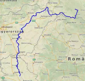 Map of the Tisza | |
| Location | |
| Countries | |
| Towns |
|
| Physical characteristics | |
| Source | |
| - location | Eastern Carpathians, Ukraine |
| - elevation | 2,020 m (6,630 ft) |
| Mouth | Danube |
| - location | Downstream of Novi Sad, Serbia |
| - coordinates | 45°8′17″N 20°16′39″E[1] |
| Length | 966 km (600 mi) |
| Basin size | 156,087 km2 (60,266 sq mi)[2] 154,073.1 km2 (59,488.0 sq mi)[3] |
| Discharge | |
| - location | Novi Slankamen, Serbia (near mouth) |
| - average | 820 m3/s (29,000 cu ft/s) 920.111 m3/s (32,493.4 cu ft/s)[3] |
| - minimum | 160 m3/s (5,700 cu ft/s) |
| - maximum | 4,500 m3/s (160,000 cu ft/s) |
| Discharge | |
| - location | Szeged, Hungary (173.6 km upstream of mouth - Basin size: 138,857.7 km2 (53,613.3 sq mi)[3] |
| - average | 769 m3/s (27,200 cu ft/s) 890.451 m3/s (31,446.0 cu ft/s)[3] |
| Discharge | |
| - location | Szolnok, Hungary (334.6 km upstream of mouth - Basin size: 72,889.4 km2 (28,142.8 sq mi)[3] |
| - average | 546 m3/s (19,300 cu ft/s) 578.922 m3/s (20,444.4 cu ft/s) |
| Discharge | |
| - location | Tokaj, Hungary (543.079 km upstream of mouth - Basin size: 49,120.9 km2 (18,965.7 sq mi)[3] |
| - average | 465 m3/s (16,400 cu ft/s) 468.77 m3/s (16,554 cu ft/s)[3] |
| Discharge | |
| - location | Vásárosnamény, Hungary (684.45 km upstream of mouth - Basin size: 30,978.9 km2 (11,961.0 sq mi)[3] |
| - average | 340.62 m3/s (12,029 cu ft/s)[3] |
| Basin features | |
| Progression | Danube→ Black Sea |
| Tributaries | |
| - left | Someș, Körös, Mureș, Bega |
| - right | Bodrog, Sajó, Eger, Zagyva |
Names for the river in the countries it flows through are:
Tributaries
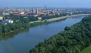
River Tisza & Bodrog at Tokaj from above
- Čik (near Bačko Petrovo Selo)
- Jegrička (near Žabalj)
- Begej (near Titel)
- Mureş (in Szeged)
- Arieş (near Gura Arieşului)
- Târnava (near Teiuş)
- Târnava Mare (in Blaj)
- Târnava Mică (in Blaj)
- Körös (near Csongrád)
- Crişul Repede River (near Gyoma)
- Barcău (in Szeghalom)
- Crişul Alb (near Gyula)
- Crişul Negru (near Gyula)
- Crişul Repede River (near Gyoma)
- Zagyva (in Szolnok)
- Sajó (in Tiszaújváros)
- Hornád (near Miskolc)
- Bodrog (in Tokaj)
- Crasna (in Vásárosnamény)
- Someş (near Vásárosnamény)
- Tur
- Batár
- Şugătag
- Baia
- Şaroş
- Săpânţa
- Valea Hotarului
- Bicu
- Sarasău
- Valea Iepei
- Iza
- Mara
- Vişeu
Sources
- Administraţia Naţională Apelor Române - Cadastrul Apelor - Bucureşti
- Institutul de Meteorologie şi Hidrologie - Rîurile României - Bucureşti 1971
References
- Tisza at GEOnet Names Server
- Tockner, Klement; Uehlinger, Urs; Robinson, Christopher T., eds. (2009). Rivers of Europe (First ed.). London: Academic Press. Sec. 3.9.5. ISBN 978-0-12-369449-2.
- "Rivers Network". 2020. Archived from the original on 2022-10-12. Retrieved 2022-10-25.
This article is issued from Wikipedia. The text is licensed under Creative Commons - Attribution - Sharealike. Additional terms may apply for the media files.