Tescott, Kansas
Tescott is a city in Ottawa County, Kansas, United States. In 2020, 265 people lived there.[3]
Tescott, Kansas | |
|---|---|
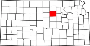
 Location within Ottawa County and Kansas | |
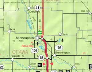 KDOT map of Ottawa County (legend) | |
| Coordinates: 39°0′43″N 97°52′41″W[1] | |
| Country | United States |
| State | Kansas |
| County | Ottawa |
| Founded | 1860s |
| Platted | 1866 |
| Incorporated | 1905 |
| Named for | T.E. Scott |
| Area | |
| • Total | 0.39 sq mi (1.00 km2) |
| • Land | 0.39 sq mi (1.00 km2) |
| • Water | 0.00 sq mi (0.00 km2) |
| Elevation | 1,293 ft (394 m) |
| Population | |
| • Total | 265 |
| • Density | 680/sq mi (270/km2) |
| Time zone | UTC-6 (CST) |
| • Summer (DST) | UTC-5 (CDT) |
| ZIP code | 67484 |
| Area code | 785 |
| FIPS code | 20-70250 |
| GNIS ID | 2396044[1] |
| Website | cityoftescott.com |
History
Tescott was planned out in 1866.[4] The city was named after T.E. Scott, an early settler.[5][6]
On May 1st 2018, an EF3 wedge tornado hit the area near the city. It damaged one house.
Geography
Tescott is at 39°0′43″N 97°52′41″W (39.012005, -97.878140).[7] The United States Census Bureau, the city has a total area of 0.39 square miles (1.01 km2). All of it is land.[2]
Weather
Tescott has hot, humid summers and generally mild to cool winters. The Köppen Climate Classification system says that Tescott has a humid subtropical climate, abbreviated "Cfa" on climate maps.[8]
People
| Historical population | |||
|---|---|---|---|
| Census | Pop. | %± | |
| 1910 | 421 | — | |
| 1920 | 377 | −10.5% | |
| 1930 | 382 | 1.3% | |
| 1940 | 402 | 5.2% | |
| 1950 | 412 | 2.5% | |
| 1960 | 396 | −3.9% | |
| 1970 | 393 | −0.8% | |
| 1980 | 331 | −15.8% | |
| 1990 | 317 | −4.2% | |
| 2000 | 339 | 6.9% | |
| 2010 | 319 | −5.9% | |
| 2020 | 265 | −16.9% | |
| U.S. Decennial Census | |||
Tescott is part of the Salina Micropolitan Statistical Area.
2020 census
The 2020 census says that there were 265 people, 121 households, and 68 families living in Tescott. Of the households, 82.6% owned their home and 17.4% rented their home.
The median age was 48.8 years. Of the people, 89.1% were White, 0.4% were Native American, 0.4% were from some other race, and 10.2% were two or more races. Hispanic or Latino of any race were 1.9% of the people.[3][9]
Education
Tescott is part of Twin Valley USD 240 school district. The district has two high schools; Bennington High School and Tescott High School.[11]
References
- U.S. Geological Survey Geographic Names Information System: Tescott, Kansas
- "2020 U.S. Gazetteer Files". United States Census Bureau. Retrieved November 30, 2023.
- "DP1: PROFILE OF GENERAL POPULATION AND HOUSING CHARACTERISTICS". United States Census Bureau. Retrieved November 30, 2023.
- Kansas State Historical Society (1916). Biennial Report of the Board of Directors of the Kansas State Historical Society. Kansas State Printing Plant. p. 259.
- Heim, Michael (2007). Exploring Kansas Highways. p. 37. ISBN 9780974435886.
- "Profile for Tescott, Kansas". ePodunk. Archived from the original on 14 July 2014. Retrieved 22 June 2014.
- "US Gazetteer files: 2010, 2000, and 1990". United States Census Bureau. 2011-02-12. Retrieved 2011-04-23.
- Climate Summary for Tescott, Kansas
- "P16: HOUSEHOLD TYPE". United States Census Bureau. Retrieved January 2, 2024.
- "American FactFinder". United States Census Bureau. Retrieved 2012-07-06.
- "Twin Valley USD 240". USD 240. Retrieved 6 January 2017.
Other websites
- City
- Schools
- USD 240, local school district
- Maps
- Tescott City Map, KDOT
Municipalities and communities of Ottawa County, Kansas, United States | ||
|---|---|---|
| Cities |
|  Map of Kansas highlighting Ottawa County |
| CDP |
| |
| Unincorporated communities |
| |