Telford and Wrekin
Telford and Wrekin is a unitary authority district and borough in the West Midlands of England. It is part of the ceremonial county of Shropshire. It borders Staffordshire.
Telford and Wrekin | |
|---|---|
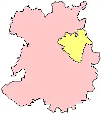 Telford and Wrekin (in yellow) shown within Shropshire (in pink) | |
| Coordinates: 52°40′52″N 2°26′19″W | |
| Sovereign State | United Kingdom |
| Country | England |
| Region | West Midlands |
| Ceremonial county | Shropshire |
| Admin HQ | Telford |
| Established | 1998 |
| Government | |
| Area | |
| • Total | 112.09 sq mi (290.31 km2) |
| Population | |
| • Total | 166,800 |
| • Density | 1,500/sq mi (570/km2) |
| Time zone | GMT |
| ISO 3166 code | GB-TFW |
| Website | www |
The district was created in 1974 and was called The Wrekin.
It is the only separate unitary authority in Shropshire. It shares its Fire and Rescue Service and Community Health with the rest of the county.
The biggest town in the borough is Telford. The borough also includes the towns of Wellington, Shifnal, Bridgnorth and Newport.
Wards
The borough contains 30 wards.
 |
1 - Admaston and Bratton
2 - Apley Castle 3 - Arleston 4 - Brookside 5 - Church Aston and Lilleshall 6 - College 7 - Dawley and Aqueduct 8 - Donnington 9 - Dothill 10 - Edgmond and Ercall Magna 11 - Ercall 12 - Hadley and Leegomery 13 - Haygate 14 - Horsehay and Lightmoor 15 - Ironbridge Gorge |
16 - Ketley and Overdale
17 - Madeley and Sutton Hill 18 - Malinslee and Dawley Bank 19 - Muxton 20 - Newport North and West 21 - Newport South and East 22 - Oakengates and Ketley Bank 23 - Park 24 - Priorslee 25 - Shawbirch 26 - St Georges 27 - The Nedge 28 - Woodside 29 - Wrockwardine 30 - Wrockwardine Wood and Trench |
Gallery
 Ironbridge Gorge
 The Wrekin
 Telford Shopping Centre