Tangipahoa Parish, Louisiana
Tangipahoa Parish is a parish in the U.S. State of Louisiana. The parish was put together from parts of 4 other parishes in 1869. Before it was a parish, many slaves were forced to work on sugar plantations in the area. After the Civil War, the white people continued to be very violent towards the black people they had enslaved. All across the south, there were lynchings against black people. Tangipahoa Parish had more lynchings than any nearby parish.[1]
Tangipahoa Parish | |
|---|---|
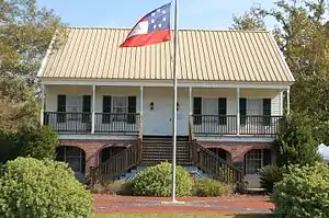 Museum at Camp Moore | |
 Location within the U.S. state of Louisiana | |
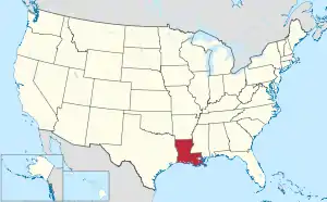 Louisiana's location within the U.S. | |
| Coordinates: 30°37′36″N 90°24′20″W | |
| Country | |
| State | |
| Founded | March 6, 1869 |
| Named for | Acolapissa word meaning ear of corn or those who gather corn |
| Seat | Amite City |
| Largest city | Hammond |
| Area | |
| • Total | 844 sq mi (2,186 km2) |
| • Land | 791 sq mi (2,049 km2) |
| • Water | 53 sq mi (137 km2) 6.3% |
| Population (2020) | |
| • Total | 133,157 |
| • Density | 168.3/sq mi (65.0/km2) |
| Time zone | UTC−6 (Central) |
| • Summer (DST) | UTC−5 (CDT) |
| Area code | 985 |
| Congressional districts | 1st, 5th |
| Website | www |
References
- Michael James Pfeifer, Rough Justice: Lynching and American Society, 1874-1947, University of Illinois Press, 2004, pp. 83-84
Other websites
- Visitor's Bureau website, Tangipahoa history Archived 2011-05-18 at the Wayback Machine
Municipalities and communities of Tangipahoa Parish, Louisiana, United States | ||
|---|---|---|
| Cities | | |
| Towns | ||
| Villages | ||
| CDP | ||
| Other Unincorporated communities |
| |

This article is issued from Wikipedia. The text is licensed under Creative Commons - Attribution - Sharealike. Additional terms may apply for the media files.