Spalt
Spalt is a town in Roth, in Bavaria, Germany. It is 19 km southwest of Schwabach.
Spalt | |
|---|---|
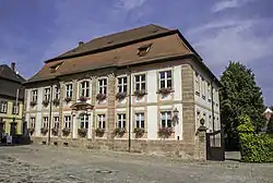 Town Hall of Spalt | |
 Coat of arms | |
Location of Spalt within Roth district 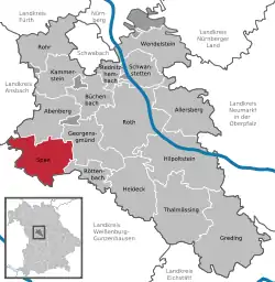 | |
 Spalt  Spalt | |
| Coordinates: 49°10′26″N 10°55′39″E | |
| Country | Germany |
| State | Bavaria |
| Admin. region | Mittelfranken |
| District | Roth |
| Subdivisions | 18 districts |
| Government | |
| • Mayor (2020–26) | Udo Weingart[1] (CSU) |
| Area | |
| • Total | 55.80 km2 (21.54 sq mi) |
| Elevation | 309 m (1,014 ft) |
| Population (2022-12-31)[2] | |
| • Total | 5,204 |
| • Density | 93/km2 (240/sq mi) |
| Time zone | UTC+01:00 (CET) |
| • Summer (DST) | UTC+02:00 (CEST) |
| Postal codes | 91174 |
| Dialling codes | 09175 |
| Vehicle registration | RH, HIP |
| Website | www.spalt.de |
Geography
Spalt is between Nuremberg, Ansbach, and Treuchtlingen in the north of the Franconian lakelands. In the southwest of the city is the Great Brombachsee and its dam. The Fränkische Rezat flows through Georgensgmünd into the Rednitz.
Neighboring communities
(starting in the north and going clockwise)
Division of the town
The following places belong to the community of Spalt:
Egelmühle, Enderndorf, Engelhof, Fünfbronn, Großweingarten, Güsseldorf, Hagsbronn, Heiligenblut, Hohenrad, Höfstetten, Hügelmühle, Kaltenbrunn, Keilberg, Massendorf, Mosbach, Mühlreisig, Nagelhof, Ottmannsberg, Schnittling, Steinfurt, Stiegelmühle, Stockheim, Straßenhaus, Theilenberg, Trautenfurt, Untererlbach, Wasserzell, Wernfels
Sister Cities
- Bad Sauerbrunn, Austria
- Saint Cloud, Minnesota, United States
References
- Liste der ersten Bürgermeister/Oberbürgermeister in kreisangehörigen Gemeinden, Bayerisches Landesamt für Statistik, 15 July 2021.
- Genesis Online-Datenbank des Bayerischen Landesamtes für Statistik Tabelle 12411-003r Fortschreibung des Bevölkerungsstandes: Gemeinden, Stichtag (Einwohnerzahlen auf Grundlage des Zensus 2011) .
Other websites
Wikimedia Commons has media related to Spalt.
- Official site (in German)
Towns and municipalities in Roth (district) | ||
|---|---|---|
This article is issued from Wikipedia. The text is licensed under Creative Commons - Attribution - Sharealike. Additional terms may apply for the media files.