Sierra Madre del Sur
The Sierra Madre del Sur (Spanish for "Southern part of the Mother Range") is a mountain range. It is in Mexico, Honduras, and Guatemala.[1]
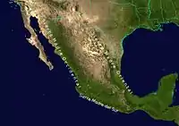
Map of the Sierra Madre range
The Sierra Madre del Sur is about 620 miles long (1000 km) and runs northwest-southeast along the south coast of Mexico. It touches the Trans-Mexican Volcanic Belt. Its highest mountain is 12,149 feet (3703 meters) above sea level.[1]
There are pine-oak forests and cloud forests in the Sierra Madre del Sur. Many animals and plants live there. Scientists call this biodiversity.[1][2]
References
- "Sierra Madre Mountain System (Mexico, Central America)". Latin America and Caribbean Geographic. April 10, 2019. Retrieved January 31, 2022.
- "Fires in Mexico's Sierra Madre del Sur". NASA Earth Observatory. May 17, 2005. Retrieved February 2, 2022.
This article is issued from Wikipedia. The text is licensed under Creative Commons - Attribution - Sharealike. Additional terms may apply for the media files.