Interstate 605
Interstate 605 (I-605), also called the San Gabriel River Freeway, is an Interstate Highway in the Orange and Los Angeles counties of California. It is a spur route of the Interstate 5. It goes from the Interstate 405 in Seal Beach north to the Interstate 210 in Duarte. It runs next to the San Gabriel River for most of its route. The Interstate is about 27 miles (43 km) long.[3]
Interstate 605 | ||||
|---|---|---|---|---|
| San Gabriel River Freeway | ||||
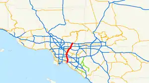 I-605 highlighted in red | ||||
| Route information | ||||
| Auxiliary route of I-5 | ||||
| Maintained by Caltrans | ||||
| Length | 27.40 mi[1] (44.10 km) | |||
| History | 1940s as a state highway, 1964 as a number[2] | |||
| NHS | Entire route | |||
| Major junctions | ||||
| South end | ||||
| ||||
| North end | ||||
| Location | ||||
| Country | United States | |||
| State | California | |||
| Counties | Orange, Los Angeles | |||
| Highway system | ||||
| ||||
| ||||
.svg.png.webp)
Exits
| County | Location | mi[4][5] | km | Exit[4] | Destinations | Notes |
|---|---|---|---|---|---|---|
| Orange | Seal Beach | 0.00 | 0.00 | 1A | Southern terminus; SR 22 exit 2 | |
| 0.41 | 0.66 | 1B | Southbound exit and northbound entrance; former SR 7 south; I-405 north exit 24 | |||
| — | HOV access only; southbound exit and northbound entrance | |||||
| 1C | Signed as exit 1A northbound; former SR 7 north; I-405 south exit 24A | |||||
| Los Alamitos | 1.41 | 2.27 | 1D | Katella Avenue / Willow Street – Los Alamitos | Signed as exit 1B northbound; Willow St. not signed southbound | |
| Coyote Creek | 1.60 | 2.57 | Bridge | |||
| Los Angeles | Long Beach | 1.69 | 2.72 | 2A | Willow Street | Southbound exit only |
| 1.93 | 3.11 | 2B | Spring Street / Cerritos Avenue | Southbound exit and northbound entrance | ||
| Long Beach–Lakewood line | 3.38 | 5.44 | 3 | Carson Street / Lincoln Avenue – Hawaiian Gardens | Former US 91 and SR 18 | |
| Lakewood–Cerritos line | 4.51 | 7.26 | 5A | Del Amo Boulevard – Lakewood | ||
| Cerritos | 5.39 | 8.67 | 5B | South Street | ||
| 6.69 | 10.77 | 7A | ||||
| Cerritos–Norwalk line | 7.45 | 11.99 | 7B | Alondra Boulevard | ||
| Norwalk | 8.50 | 13.68 | 9A | Rosecrans Avenue | ||
| 9.29 | 14.95 | 9B | I-105 east exits 18A-B | |||
| 9.29 | 14.95 | 9C | Imperial Highway | Signed as exit 9B southbound; former SR 90 | ||
| 9.53 | 15.34 | 10 | Firestone Boulevard | Former SR 42 | ||
| Downey | 11.25 | 18.11 | 11 | Florence Avenue – Downey | ||
| Downey–Santa Fe Springs line | 11.25 | 18.11 | 11 | Former US 101 Byp. south; I-5 exit 124 | ||
| Santa Fe Springs | 11.89 | 19.14 | 12 | Telegraph Road – Santa Fe Springs | Former US 101 Byp. north; former SR 26 | |
| West Whittier-Los Nietos | 13.18 | 21.21 | 13 | Slauson Avenue | ||
| 13.69 | 22.03 | 14 | Washington Boulevard – Pico Rivera | Signed as exits 14A (west) and 14B (east) southbound | ||
| West Whittier-Los Nietos–Whittier line | 15.21 | 24.48 | 15 | Former US 101 | ||
| Whittier–Pico Rivera line | 16.05 | 25.83 | 16 | Beverly Boulevard | Southbound access to Beverly Blvd. west is via exit 17 | |
| Pico Rivera–Industry line | 17.21 | 27.70 | 17 | Rose Hills Road | ||
| Industry | 18.29 | 29.43 | 18 | Peck Road | ||
| Industry–Avocado Heights line | 19.05 | 30.66 | 19 | SR 60 exit 12 | ||
| 21.03 | 33.84 | 21 | Valley Boulevard – Industry | Former US 60 and SR 212 | ||
| Baldwin Park | 21.83 | 35.13 | 22 | Former US 99 / US 70 / US 60; I-10 east exits 31A-B, west exit 31A | ||
| Baldwin Park–Irwindale line | 22.71 | 36.55 | 23 | Ramona Boulevard – Baldwin Park, El Monte | Former US 99 | |
| Irwindale | 23.79 | 38.29 | 24 | Lower Azusa Road / Los Angeles Street | ||
| 25.16 | 40.49 | 25 | Live Oak Avenue – Irwindale | Northbound exit and southbound entrance | ||
| 26.60 | 42.81 | 26 | Arrow Highway | Southbound exit and northbound entrance | ||
| 27.40 | 44.10 | 27 | Unsigned exits 27A (east) and 27B (west); I-210 east exit 36A, west exit 36B | |||
| Duarte | 27.54 | 44.32 | 27C | Huntington Drive (Historic US 66) – Duarte | Northern terminus; at-grade intersection; former US 66; road continues as Mount Olive Drive | |
1.000 mi = 1.609 km; 1.000 km = 0.621 mi
| ||||||
References
- "Route Log and Finder List - Interstate System: Table 2". FHWA. Retrieved October 7, 2007.
- "Los Angeles Highways". Scvresources.com. Archived from the original on November 15, 2011. Retrieved January 26, 2013.
- Federal Highway Administration (March 25, 2015). National Highway System: Los Angeles, CA (PDF) (Map). Scale not given. Washington, DC: Federal Highway Administration. Retrieved July 29, 2017.
- Warring, KS (April 18, 2008). "Interstate 605 Freeway Interchanges" (PDF). California Numbered Exit Uniform System. California Department of Transportation. Retrieved September 1, 2014.
- "California Log of Bridges on State Highways: District 12" (PDF). Caltrans. California Department of Transportation. October 2006. Archived from the original (PDF) on February 20, 2007. Retrieved September 19, 2019.
This article is issued from Wikipedia. The text is licensed under Creative Commons - Attribution - Sharealike. Additional terms may apply for the media files.