Province of Latina
The Province of Latina (Italian: Provincia di Latina) is a province in the Lazio region of Central Italy. Its capital is the city of Latina.
Province of Latina | |
|---|---|
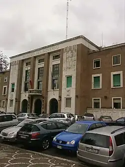 Palazzo del Governo, province headquarters. | |
 Flag | |
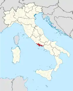 Map with the province of Latina, in red, in Italy | |
| Coordinates: 41°28′3.35″N 12°54′13.32″E | |
| Country | |
| Region | Lazio |
| Capital | Latina |
| Comuni | 33 |
| Government | |
| • President | Eleonora Della Penna[1] |
| Area | |
| • Total | 2,256.16 km2 (871.11 sq mi) |
| Population (January 2017)[3] | |
| • Total | 574,891 |
| • Density | 250/km2 (660/sq mi) |
| Time zone | UTC+1 (CET) |
| • Summer (DST) | UTC+2 (CEST) |
| Postal code | 04100 Latina, 04010-04032 |
| Telephone prefix | 06, 0771, 0773 |
| Vehicle registration | LT |
| ISTAT | 059 |
| Website | Official website |
History
The province of Latina was created in December of 1934 with the name of Littoria.
Geography
.svg.png.webp)
The province of Latina has an area of 2,256.16 km2 (871.11 sq mi),[2] the smallest province of the Lazio region.
The province is in the southwest of the Lazio region. It borders to the north with the Frosinone province, to the northwest and west with the Metropolitan City of Rome, to the southeast with the Campania region (Caserta), and to the south with the Tyrrhenian Sea (Mediterranean Sea).
Places next to Province of Latina | ||||||||||
|---|---|---|---|---|---|---|---|---|---|---|
| ||||||||||
The highest mountain in the province is Monte Petrella (41°19′20″N 13°39′56″E), with an altitude of 1,533 m (5,030 ft).[4]
Population
In 2017, there are 574,891 persons living in the province,[3] for a population density of 254.8 inhabitants/km².
Evolution of the population in the province of Latina

Administration
There are 33 municipalities (or comuni) in the province; they are:
- Aprilia
- Bassiano
- Campodimele
- Castelforte
- Cisterna di Latina
- Cori
- Fondi
- Formia
- Gaeta
- Itri
- Latina
- Lenola
- Maenza
- Minturno
- Monte San Biagio
- Norma
- Pontinia
- Ponza
- Priverno
- Prossedi
- Rocca Massima
- Roccagorga
- Roccasecca dei Volsci
- Sabaudia
- San Felice Circeo
- Santi Cosma e Damiano
- Sermoneta
- Sezze
- Sonnino
- Sperlonga
- Spigno Saturnia
- Terracina
- Ventotene
The largest comune is Latina, with 277.62 km2 (107.19 sq mi) and the smallest is Ventotene (1.75 km2 [0.68 sq mi] ).[5] The comune with fewest people living in it is Campodimele with 622 inhabitants.
Main comuni
The following table shows the 10 comuni with more inhabitants with their population,[3] and their area and altitude.[6]
| No. | Comune | Population (2017) | Area (km²) | Density | Altitude (m) |
|---|---|---|---|---|---|
| 1 | Latina | 126,151 | 277.62 | 454.4 | 21 |
| 2 | Aprilia | 73,934 | 178.11 | 415.1 | 80 |
| 3 | Terracina | 46,131 | 136.59 | 337.7 | 22 |
| 4 | Fondi | 39,736 | 143.92 | 276.1 | 8 |
| 5 | Formia | 38,145 | 74.17 | 514.3 | 19 |
| 6 | Cisterna di Latina | 36,923 | 144.16 | 256.1 | 77 |
| 7 | Sezze | 24,876 | 100.47 | 247.6 | 319 |
| 8 | Gaeta | 20,674 | 29.20 | 708.0 | 2 |
| 9 | Sabaudia | 20,613 | 145.37 | 141.8 | 17 |
| 10 | Minturno | 19,734 | 42.14 | 468.3 | 141 |
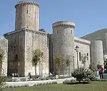
Gallery


Related pages
- List of communes of the Province of Latina
References
- "Il Presidente" (in Italian). Provincia di Latina. Retrieved 20 August 2017.
- "Provincia di Latina" (in Italian). Tuttitalia.it. Retrieved 20 August 2017.
- "Statistiche demografiche ISTAT" (in Italian). Demo.istat.it. Archived from the original on 3 January 2018. Retrieved 20 August 2017.
- "Monte Petrella, Italy". Peakbagger.com. Retrieved 20 August 2017.
- "Comuni in provincia di Latina per superficie" (in Italian). Tuttitalia.it. Retrieved 20 August 2017.
- "Comuni in provincia di Rieti per popolazione" (in Italian). Tuttitalia.it. Retrieved 30 June 2017.
Other websites
- Official Site (in Italian)